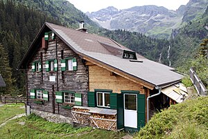
Hans Wödl Hut
| Hans-Wödl-Hütte AGP refuge category I |
||
|---|---|---|
| location | Seewigtal; Styria , Austria ; Valley location: Gössenberg | |
| Mountain range | Schladminger Tauern | |
| Geographical location: | 47 ° 21 '39.3 " N , 13 ° 49' 0.9" E | |
| Altitude | 1533 m above sea level A. | |
|
|
||
| owner | Alpine Society Preintaler | |
| Built | 1897 | |
| Construction type | Refuge | |
| Usual opening times | Mid June to early October | |
| accommodation | 8 beds, 56 camps | |
| Web link | Hans Wödl Hut | |
| Hut directory | PES | |
The Hans-Wödl-Hütte is a hut of the Alpine Society Preintaler (AGP) in the Schladminger Tauern in the Austrian state of Styria .
location
The hut is located north of the Hüttensee at an altitude of 1533 m, about 25 meters above the lake, almost at the end of the Seewig valley. The ÖK 50 only specifies a height of 1528 m .
history
The hut was named after the developer of the Schladminger Tauern and the then chairman of the Alpine Society Preintaler (AGP), Hans Wödl (1863-1937). It was built between 1896 and 1897 as the AGP's second refuge and opened on June 6, 1897. Just like the other two AGP huts, it was designed according to the Pott system (provision of provisions with subsequent payment slip ) and was managed in the summer from 1903.
Ascent
- from Styrian Lake Constance , 1157 m , walking time 1½ hours
- Aich / Assach train station , walking time 3 hours
- Toll road from Ruperting or Aich, walking time 3 hours
- Cable car Haus - Hauser Kaibling (via Krummholzhütte), walking time 5 hours
Tours
- Höchstein , 2543 m , walking time 3 hours ascent
- Hochwildstelle : 2747 m , walking time 4 hours ascent
- Höhenweg to Planai , 1846 m , walking time 8 hours
- possible start of the Schladminger-Tauern-Höhenweg to Obertauern
- 2-day tour via the Preintalerhütte to the Gollinghütte
Transition to other huts
- Preintalerhütte , 1656 m , walking time 6 hours
- Pleschnitzzinkenhütte, 1927 m , walking time 3¾ hours
- Schladminger Hütte, 1830 m , walking time 8 hours
- Krummholzhütte, 1838 m , walking time 6 hours
- Naturfreundehaus Kaiblingalm, 1784 m , walking time 5 hours
Web links
Commons : Hans-Wödl-Hütte - Collection of pictures, videos and audio files

