Hardau (Winterthur)
|
Hardau quarter of Winterthur |
|
|---|---|
| Coordinates | 693 371 / 263315 |
| height | 406 m |
| surface | 0.66 km² |
| Residents | 315 (Dec. 31, 2019) |
| Population density | 477 inhabitants / km² |
| BFS no. | 230-660 |
| Post Code | 8408 |
| Urban district | Wülflingen (District 6) |
Hardau is a district of the city of Winterthur . Together with the quarters Weinberg , Oberfeld , Lindenplatz , Niederfeld , Neuburg , Härti and Taggenberg , it belongs to District 6 ( Wülflingen ).
geography
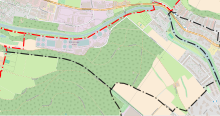
Hardau is located at the western end of Wülflingen and thus also at the western end of the city itself. The built-up part of the quarter can be divided into the Hardau settlement adjacent to the Niederfeld settlement and the Hardau factory area 300 meters to the west. At the western end of the district there is still the Hard sewage treatment plant, which is shielded from the rest of the district by the Hardholz forest. To the west of the Hard sewage treatment plant, on the border with Pfungen, lies the lowest point in the city of Winterthur at 393 meters.
The district shares only a small borderline at the western end with the aforementioned municipality of Pfungen, but the shared border with the municipality of Neftenbach in the northwest is larger . Towards the south-west, the district borders the district of Neuburg along the Winterthur – Bülach railway line between the Hardholz and Beerenberg forests . In the southeast is the Niederfeld district, half of the border runs along fields and the settlement boundary. Only shortly before the Töss does the border cross a row of houses at Hardgutstrasse. In the northeast, the border finally runs along the Töss, on the other side of the river is the Härti district.
education
The pupils from the neighborhood attend kindergarten and primary school in the Wyden schoolhouse in neighboring Niederfeld. The Hohfurri secondary school is located in the east of Wülflingen at the western end of the Oberfeld district.
history
The settlement that gives the quarter its name is a former workers' quarter with 82 houses . It was built between 1943 and 1946 by the «Langgasse» building cooperative in response to the worsening housing shortage. The construction site was chosen deliberately because the gravelly subsoil covered with little humus was not very suitable for agriculture. The deliberately small double family houses were inhabited by large families at that time. In order to preserve the appearance of the settlement, there is a design plan for the Hardau.
The factory area of the former Hard spinning mill also belongs to the quarter . This was built in 1801/02 and was believed to be the first factory and machine spinning mill in continental Europe. After the decline of the spinning mill in February 1924, the factory was first taken over by the Neftenbach button factory, which ceased operations four years later. After that, the new owner was a plastic injection / pressing plant, which operated there until it went bankrupt in 1985. As early as 1935, the first Swiss vocational camp for unemployed young metal workers was founded in the Hard (today located as the Swiss Technical College in the Schlosstal), which remained on the site until 1962. Today the area is managed by the Hard community and offers living space and workplaces for around 140 people each.
At the western end of the quarter is the Hard wastewater treatment plant , which went into operation in 1951 , separated from the rest of the quarter by the Hardholz forest.
Transport links
The “Hardau” bus stop for bus line 7 (HB - Wülflingen station) from Stadtbus Winterthur is located in the immediate vicinity of the Hardau housing estate (but outside the district) . The Winterthur-Wülflingen train station , where the S41 (Winterthur - Bülach - Zurzach - Waldshut) stops, is also just a few minutes away from Hardau . On weekends, the N59 night bus (Winterthur - Storchenbrücke - Schlosstal - Wülflingen train station) runs on the route of bus line 7, which serves the Hardau bus stop to get off the city. Wülflingen station is served by the Winterthur – Bülach night train.
Depending on your preference, the “Wülflingen” terminus of the regular trolleybus line 2 (Wülflingen - HB - Seen) or the “Haltereben” stop are closer to the three regional bus routes 665, 667 and 670 that stop in the direction of Neftenbach are on the way, stop. Both stops are served by the night bus route N67 (Winterthur - Neftenbach - Pfungen - Dättlikon) on weekends.
Web links
- District association Hardau
- Community Hard
- Hardau settlement in Winterthur glossary.
- Hard, Spinnerei im Winterthur Glossary.
Individual evidence
- ^ F. Scheibler: The colony in the Hardau of the building cooperative "Langgasse", Winterthur . In: Living . tape 22 , no. 7 , 1947, pp. 167–168 ( e-periodica.ch [PDF; accessed on August 11, 2016]).

