
Taggenberg
|
quarter of Winterthur |
|
|---|---|
 |
|
| Coordinates | 693 790 / 263.99 thousand |
| height | 436 m |
| surface | 2.23 km² |
| Residents | 1112 (Dec. 31, 2019) |
| Population density | 499 inhabitants / km² |
| BFS no. | 230-680 |
| Post Code | 8408 |
| Urban district | Wülflingen (District 6) |

Taggenberg is a district of the city of Winterthur . Together with the quarters Weinberg , Oberfeld , Lindenplatz , Niederfeld , Neuburg , Hardau and Härti , it belongs to District 6 ( Wülflingen ).
geography
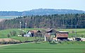
Taggenberg is partly on a slope and in the north of the Wülflingen district. Only the southernmost part of the quarter (Maienried) is built on, otherwise there are only a few farms in the area of the quarter with the Upper and Lower Radhof and the Taggenberg, which cultivate the surrounding agricultural land. The Taggenberg hill, which gives it its name, is located in the far west of the district, with its highest point in the area of the municipality of Neftenbach .
The district shares a border with Wülflingen in the south with the Härti district along the Haltreben and Salomon-Hirzel-Strasse and in the east along the A1 motorway with the Weinberg district. To the northeast, Taggenberg borders the municipality of Seuzach and, in a narrow strip, the municipality of Hettlingen . The district has the largest common border with the Neftenbach in the north and west.
education
The pupils attend kindergarten and primary school in the kindergartens and primary schools in the neighborhood. The upper level is in the Oberfeld district.
history
The Taggenberg was an agricultural area until the 1970s. Apart from a few buildings and the Taggenberg, Unterer and Oberer Radhof farms, there are still no residential developments on the Maienried, which is now built over. In the 19th century, the Obere Radhof belonged to the civil parish of Wülflingen, while the residents of the Untere Radhof and Taggenberg were only residences with fewer rights, e.g. B. also with regard to logging in the municipality. In the 18th century they also had to fight for their rights to church and poor property as well as attending free schools. When, due to a legal reform in 1823, all residents had to acquire citizenship status in a civil parish and the demands of the civil parish of Wülflingen were too high, the twelve residents of the two farms founded the civil parish Unterrad-Taggenberg with the consent of the canton . The civil parish existed for a good 50 years. On the occasion of a new cantonal municipal law, it was repealed in 1876 and this time integrated into the civil parish of Wülflingen without additional requirements.
The first development in Maienried, comprising twelve multi-family houses, was built in the early 1970s in Fuchshalde. The quarter experienced a real growth spurt again in the new millennium, when further developments were built. Before that, the hamlet of Lantig was built in the first half of the 1920s along the train line to Schaffhausen, with a population of around 50 today.
In 2002, the Winterthur Taggenberg wind farm went into operation in Taggenberg .
Transport links
There is no bus connection through the quarter itself, the next bus line is bus line 2 (Wülflingen – HB – Seen), which runs along Wülflingerstrasse. The Winterthur-Wülflingen motorway junction is also easily accessible.
Culture and leisure
- The soccer field Sporrer of FC Wülflingen is located slightly outside Wülflingen in the Taggenberg district.
- The Bambole Openair takes place on the Upper Radhof at irregular intervals.
- The Langwiesen-Maienried district association has its leisure facility south of the district.
- The Taggenberg restaurant has been awarded Gault Millau points for years .

View from the south
Taggenberg farm

Taggenberg restaurant

terrace


Web links
Individual evidence
- ^ Peter Ziegler: Wülflingen . In: 305th New Year's sheet of the Winterthur City Library . Winterthur 1975, p. 177-178 .
- ^ Hans Bernhard: The "Lantig" settlement works. A practical result of Winterthur's settlement policy . In: Schweizerische Bauzeitung . tape 79/80 , no. 16 . Winterthur April 22, 1922, p. 207–213 ( e-periodica.ch [PDF; 8.3 MB ; accessed on September 1, 2016]).
Vineyard | Oberfeld | Lindenplatz | Niederfeld | Neuburg | Hardau | Härti | Taggenberg