Hettlingen ZH
| ZH is the abbreviation for the canton of Zurich in Switzerland and is used to avoid confusion with other entries of the name Hettlingen . |
| Hettlingen | |
|---|---|
| State : |
|
| Canton : |
|
| District : | Winterthur |
| BFS no. : | 0221 |
| Postal code : | 8442 |
| Coordinates : | 695 684 / 267 145 |
| Height : | 433 m above sea level M. |
| Height range : | 420-517 m above sea level M. |
| Area : | 5.90 km² |
| Residents: | 3148 (December 31, 2018) |
| Population density : | 534 inhabitants per km² |
|
Proportion of foreigners : (residents without citizenship ) |
9.1% (December 31, 2018) |
| Mayor : | Bruno Kräuchi ( FDP ) |
| Website: | www.hettlingen.ch |
|
The village of Hettlingen |
|
| Location of the municipality | |

Hettlingen is a municipality in the Winterthur district of the canton of Zurich in Switzerland . The village belongs to the agglomeration of the city of Winterthur .
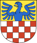
coat of arms
- Divided, at the top in gold a half blue eagle at the division, at the bottom sheathed in silver and red
geography
Hettlingen is located north of Winterthur in the hilly area of the southern Zurich wine country at the eastern foot of the Irchel chain .
The municipality Hettlingen bordered on the northwest by Henggart , on the northeast by Dägerlen , on the southeast by Seuzach , on the south by Winterthur , and on the west Neftenbach .
population
| Population development | |
|---|---|
| year | Residents |
| 1467 | approx. 205 |
| 1634 | 274 |
| 1836 | 493 |
| 1850 | 489 |
| 1900 | 462 |
| 1910 | 428 |
| 1950 | 597 |
| 1970 | 1054 |
| 2000 | 2383 |
| 2004 | 2872 |
| 2005 | 2891 |
politics
Bruno Kräuchi ( FDP ) has been mayor since 2010 (as of May 2020).
There are the following parties: FDP, GLP , PFH (Politisches Forum Hettlingen) and SVP .
In the 2019 National Council elections, the share of the vote in Hettlingen was: SVP 30.02%, glp 18.77%, FDP 16.11%, Greens 11.4%, SP 8.69%, CVP 4.71%, EPP 4.35 %, BDP 2.22%, and EDU 2.17%.
history
The first traces of settlement in Hettlingen go back to the Neolithic . The remains of a Roman manor from Roman times have been found near the church. Around 700 there was an early medieval chapel in Hettlingen and Alemannic graves from this time were found.
In 1223 the Lords of Hettlingen are first mentioned, Kyburg followers who reside in the moated castle of Hettlingen , which was demolished in 1752 . In 1434, the city of Winterthur acquired Hettlingen, who owned the village until the end of the old rule in 1798. In 1857 the village was opened up by the Rhine Falls Railway. Today the village is an agglomeration of the city of Winterthur.
Schools and kindergartens
- 2 kindergartens
- Primary school
Nature reserves
- Baldisriet
- Girls
- midfield
traffic
The Hettlingen station is served by the S 33 Winterthur - Schaffhausen and, since December 2018, the S 12 Brugg - Altstetten - Zurich HB - Stadelhofen - Winterthur - Schaffhausen / Wil of the Zurich S-Bahn.
Two postbus lines operate from Hettlingen, train station:
671 Hettlingen, Föhrenstrasse - Hettlingen, train station - Neftenbach - Winterthur, HB
677 Hettlingen, Föhrenstrasse - Hettlingen, train station - Buch am Irchel - Berg am Irchel - Flaach - Andelfingen
The Postbus lines also run through Hettlingen:
676 Henggart - Dägerlen - Hettlingen - Oberohringen - Winterthur, HB
679 Hettlingen - Unterohringen - Seuzach
Hettlingen is served by four post bus lines. There are four stops: train station, parish hall, village and Föhrenstrasse. The next motorway connection to the A1 (St. Gallen - Bern) and A4 (Winterthur - Schaffhausen) in Ohringen is three kilometers away.
Recreational facilities
Sports facilities
- gym
- Outdoor pool with diving tower (1 m and 3 m), beach volleyball field. 25 m swimming pool, non-swimmer pool and a paddling pool for the little ones
- Tennis facility with three courts
- "Witerig" shooting range (community facility of the villages of Ohringen, Seuzach and Hettlingen)
Attractions
Personalities
- Peter Spälti (1930–2010), politician and manager
literature
- Hans Martin Gubler: Art Monuments of Switzerland Volume 79 "The Art Monuments of the Canton of Zurich Volume 8: The District of Winterthur Northern Part" Society for Swiss Art History GSK Bern 1986 ISBN 3-7643-1812-0 pp. 118-144.
Web links
- Official website of the municipality of Hettlingen
- Statistical data from the canton on the municipality of Hettlingen
- Ueli Müller: Hettlingen. In: Historical Lexicon of Switzerland .
Individual evidence
- ↑ Permanent and non-permanent resident population by year, canton, district, municipality, population type and gender (permanent resident population). In: bfs. admin.ch . Federal Statistical Office (FSO), August 31, 2019, accessed on December 22, 2019 .
- ↑ Data on the resident population by home, gender and age (community profile). Statistical Office of the Canton of Zurich, accessed on December 22, 2019 .
- ↑ Elections 2019. Accessed February 25, 2020 .


