
Winterthur district
| Winterthur district | |
|---|---|
| Basic data | |
| Country: |
|
| Canton : |
|
| Main town : | Winterthur |
| FSO number : | 0110 |
| Area : | 251.75 km² |
| Height range : | 369–890 m above sea level M. |
| Residents: | 169,513 (December 31, 2018) |
| Population density : | 673 inhabitants per km² |
| map | |
 |
|
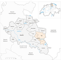
The Winterthur district is a district in the canton of Zurich in Switzerland . The core of the district, with the city of Winterthur, is more urban, the surrounding area is more rural. Some of the municipalities in the district are part of the agglomeration of the city of Winterthur.
Political communities
As of January 1, 2018
| coat of arms | Postcode | Parish name | Population (December 31, 2018) |
Area in km² |
Inhabitants per km² |
|---|---|---|---|---|---|
|
|
8479 | Altikon | 706 | 7.70 | 92 |
|
|
8311 | Brütten | 2010 | 6.60 | 305 |
|
|
8471 | Dägerlen | 1017 | 7.95 | 128 |
|
|
8421 | Dättlikon | 789 | 2.88 | 274 |
|
|
8474 | Dinhard | 1655 | 7.07 | 234 |
|
|
8353 | Elgg | 4903 | 24.39 | 201 |
|
|
8548 | Ellikon on the Thur | 901 | 5.02 | 179 |
|
|
8352 | Elsau | 3659 | 8.07 | 453 |
|
|
8523 | Hagenbuch | 1082 | 8.13 | 133 |
|
|
8442 | Hettlingen | 3148 | 5.90 | 534 |
|
|
8413 | Neftenbach | 5679 | 15.07 | 377 |
|
|
8422 | Pfungen | 3845 | 4.99 | 771 |
|
|
8545 | Rickenbach (ZH) | 2704 | 6.02 | 449 |
|
|
8418 | Schlatt (ZH) | 769 | 8.97 | 86 |
|
|
8472 | Seuzach | 7342 | 7.56 | 971 |
|
|
8488 | Turbenthal | 4900 | 25.22 | 194 |
|
|
8542 | Wiesendangen | 6521 | 19.17 | 340 |
|
|
8400 | Winterthur | 111,851 | 68.07 | 1643 |
|
|
8487 | Zell (ZH) | 6032 | 12.97 | 465 |
| Total (19) | 169,513 | 251.75 | 673 | ||
Changes in the community

Municipalities until 1921

Municipalities until 2002

Municipalities until 2012

Municipalities until 2013
Municipalities until 2017


- 1922: Merger of Oberwinterthur , Seen , Töss , Veltheim , Winterthur and Wülflingen → Winterthur
- 1922: Merger of Elsau and Schottikon → Elsau
- 2003: Change of name Hofstetten bei Elgg → Hofstetten (ZH)
- 2013: Merger of the hamlet “Obere Hueb” of the municipality of Buch am Irchel → Neftenbach
- 2014: Merger Bertschikon near Attikon and Wiesendangen → Wiesendangen
- 2018: Elgg and Hofstetten → Elgg merger
Localities
Web links
Commons : Winterthur (Bezirk) - Collection of images, videos and audio files
Individual evidence
- ↑ Permanent and non-permanent resident population by year, canton, district, municipality, population type and gender (permanent resident population). In: bfs. admin.ch . Federal Statistical Office (FSO), August 31, 2019, accessed on December 22, 2019 .
- ↑ Federal Statistical Office Generalized Limits 2020.
Districts of the Canton of Zurich