Schlatt ZH
| ZH is the abbreviation for the canton of Zurich in Switzerland and is used to avoid confusion with other entries of the name Schlatt . |
| Schlatt | |
|---|---|
| State : |
|
| Canton : |
|
| District : | Winterthur |
| BFS no. : | 0226 |
| Postal code : | 8418 |
| Coordinates : | 704 684 / 258 463 |
| Height : | 656 m above sea level M. |
| Height range : | 526–876 m above sea level M. |
| Area : | 8.97 km² |
| Residents: | 769 (December 31, 2018) |
| Population density : | 86 inhabitants per km² |
|
Proportion of foreigners : (residents without citizenship ) |
7.3% (December 31, 2018) |
| Mayor : | Urs Schäfer |
| Website: | www.schlatt-zh.ch |
|
Oberschlatt |
|
| Location of the municipality | |
Schlatt (until 1999 called Schlatt bei Winterthur ) is a political municipality in the Winterthur district of the canton of Zurich in Switzerland .
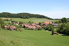
It consists of the villages of Unterschlatt , Oberschlatt , Waltenstein and Nussberg .
geography

Schlatt is located in the east of the canton of Zurich, between Winterthur and Turbenthal . Schlatt is part of the Zurich Oberland . The municipality of Schlatt borders in the north on Elsau , in the east on Elgg , in the southeast on Turbenthal, in the southwest on Zell and in the west on the district capital Winterthur (Aussenwacht Eidberg , until 1922 municipality Seen ).
46.6% of the municipal area is used for agriculture, 45.6% is forest area and 0.7% is watercourse; 2.9% is traffic area and 3.6% is settlement area. The lowest point in the municipality is at 530 m. ü. M. (Heitertal), the highest at 870 m. ü. M. (Funkenbüel).
Oberschlatt is on the Bäntalbach, Waltenstein on the Bolsternbach. Both streams flow into the Töss near Kollbrunn .
Population and politics
In 2017 Schlatt had 730 inhabitants in 282 households. 56% (410 people) were of the Reformed denomination, 12% (88 people) were Catholic. The tax rate was 128%.
In comparison, the last census in 2000 registered the number of inhabitants as 610, in 221 households, and the proportion of Reformed denominations as 75%.
Schlatt has its own primary school , which currently teaches around 95 students. The upper level is attended by the students in Elsau ( elementary school ) or in Winterthur ( grammar school ). Schlatt has had two elementary levels for several years, which integrate the preschool with the first grade into the school.
Mayor is Urs Schäfer (as of May 2020).
history
The hilly and heavily forested municipality was probably not settled until the 8th century. The villages of Schlatt and Nussberg are of Alemannic origin. Its first written mention is provided by deeds of donation to the St. Gallen monastery , the older one mentions the place Nuzperech (Nussberg) in 744 or 746 , the other one mentions 754 Sclatte (Unterschlatt). The name of the settlement Schlatt goes back to an old word for "slope, subsidence; Mulde, valley". The designation as Nidern-Schlatta is attested in 1306 ( Niderschlatt 1504), the mention of the higher-lying settlement as Ober-Schlatt , however, is only documented for 1642. The name Waltensteyn is first mentioned in 1539.
This monastic property was administered by the Lords of Schlatt (Baron Hesso von Slâte is called in 1094), who were ministerials of the Kyburg and Habsburgs in the 12th to 14th centuries . The church is mentioned in 1241 as the property of the knight Konrad von Schlatt. Waltenstein originally went back to a single large estate. In 1277 the monastery of St. Gallen gave the Vogtei Waltistal to the barons of Teufen , and in 1279 it came into Austrian hands. The Lords of Schlatt lived in the tower castle until 1361. As a result, it changed hands several times until it was converted into a rectory in 1568.
Oberschlatt belonged to the Elgg lordship, which came to Zurich in 1452 with the Kyburg county . Like Oberschlatt, Waltenstein came into Zurich ownership in 1452. The lower court rights in Oberschlatt, however, belonged to the "Steel Federation" (Stäheliner Bund) and were only acquired with this in 1494 by Zurich. From 1475 onwards, Zurich appointed the pastor. The right of collation went to Zurich in 1485 and then to Winterthur in 1529. The church was rebuilt around 1500. Members of the Furrer family, who had been living in Oberschlatt since 1543, served as Weibel or Vogt for the Zurich bailiff. The Heitertal mill near Eidberg was mentioned in 1361 and remains in operation to this day (as of 2018).
At the time of the textile home industry at the end of the 18th century, the population peaked (722 inhabitants in 1792, compared with 317 in 1634). The political community was established in 1798, initially in the Elgg district, and from 1803 in the Winterthur district.
There was no industrialization in the community, apart from a small cotton spinning mill that was operated at the Unterschlatt mill from 1825. The road to Räterschen train station was built between 1847 and 1853. An emigration began in the second half of the 19th century, the population fell from 700 in 1850 to 475 in 1960. From the 1960s onwards, the construction of single-family houses caused the population to rise again gradually to 610 people in 2000, and to 731 in 2010.
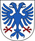
The four civil parishes retained a certain degree of independence within the political community until 1928. The municipal coat of arms , in silver, a blue double-headed eagle with red claws , was introduced by decision of the Municipal Council of 5 June 1928th It goes back to the coat of arms of the Lords of Schlatt, attested (without tinging ) in the seal of the knight Konrad von Schlatt in the document from 1279, and in the tinctures of silver and blue for the first time in the Zurich coat of arms from 1340.
Attractions
Others
- In the community there is a wide variety of trades, such as B. hairdressers, car garages, blacksmiths, beverage suppliers, architects, trust offices and driving schools.
- The post bus line 680 connects Schlatt and Oberschlatt with Winterthur and Elgg.
Personalities
- Oscar Egg (1890–1961), racing cyclist
- Barbara Ganz (* 1964), racing cyclist
- Peter Steiger (* 1960), racing cyclist
literature
- Hans Martin Gubler, Art Monuments of Switzerland Volume 76 - The Art Monuments of the Canton of Zurich Volume 7 The District of Winterthur, southern part. Society for Swiss Art History GSK, Bern 1986, ISBN 3-7643-1786-8 , pp. 240–266.
- J. Zollinger, foray into the history of the Schlatt community (1963).
- E. Ott, "Mill Heidertal in the village and school community Eidberg, in the parish Schlatt am Schauenberg and in the old county and bailiff of Kyburg", Zürcher Taschenbuch 2006 (2005), 63-108.
Web links
- Official website of the municipality of Schlatt ZH
- Statistical Office of the Canton of Zurich via Schlatt
Individual evidence
- ↑ Permanent and non-permanent resident population by year, canton, district, municipality, population type and gender (permanent resident population). In: bfs. admin.ch . Federal Statistical Office (FSO), August 31, 2019, accessed on December 22, 2019 .
- ↑ Data on the resident population by home, gender and age (community profile). Statistical Office of the Canton of Zurich, accessed on December 22, 2019 .
- ↑ http://www.statistik.zh.ch/internet/justiz_inneres/statistik/de/daten/gemeindeportraet.html
- ↑ statistik.zh.ch
- ↑ 74.9% Reformed, 12.3% Catholic, 10.2% non-denominational (2.6% were either followers of other faiths or did not provide any information). Households: 221, inhabited buildings: 181, single-family houses: 99, multi-family houses: 19, other residential buildings: 63 (2000 census)
- ↑ Schweizerisches Idiotikon IX. 762–764
- ↑ Unterschlatt (ortsnames.ch)
- ↑ Waltenstein (ortsnames.ch)
- ↑ muehleheitertal.ch ; Albert Büchi, The mill is her elixir of life , Der Tösstaler , June 22, 2016 [1] , AG founded in 2001, commercial register no. CHE-109.351.848. Ines Rütten, The mill in the Heitertal is still rattling , Der Landbote , December 22, 2016.
- ^ Ueli Müller: Schlatt ZH. In: Historical Lexicon of Switzerland . 2013 .
- ^ "The cleanup of the Zurich municipal coats of arms". In: Mitteilungen der Antiquarian Gesellschaft in Zürich 49 (1977), p. 90.


