Hartefeld
|
Hartefeld
City of Geldern
|
|
|---|---|
| Coordinates: 51 ° 29 ′ 51 ″ N , 6 ° 22 ′ 30 ″ E | |
| Height : | 30 m |
| Area : | 8.35 km² |
| Residents : | 1797 (Apr 30, 2020) |
| Population density : | 215 inhabitants / km² |
| Incorporation : | 1st July 1969 |
| Postal code : | 47608 |
| Area code : | 02831 |
|
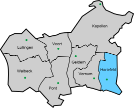
Location of Hartefeld in the city of Geldern
|
|
Hard field is a part of funds in the district of Kleve in the administrative district of Dusseldorf in North Rhine-Westphalia . 1797 inhabitants live in the village (as of April 30, 2020).
The first records of Hartefeld - back then as Hirtenveld, Hertenveld or Hardeveld (Hartesfeld) - have been around since the 13th century (1294/1295). Hartefeld was at that time an honor of the Gelderland Bailiwick (Geldern).
Hartefeld had a Catholic chapel, which was consecrated to the confessor Antonius and which was first mentioned on August 23, 1460 in a parchment document from Duke Arnold von Geldern. The slightly enlarged chapel was rebuilt and completed in 1824. In 1894 the parish church of St. Antonius was rebuilt according to plans by the architect Julius Busch. Part of the old chapel was replaced by the tower in 1901.
A Catholic kindergarten and a Catholic primary school are attached to the church. Since around 2000 there has been a municipal kindergarten, plus the volunteer fire brigade , a cemetery and a weekly market.
Hartefeld also has numerous clubs such as the Spielmannszug Blau-Weiß Hartefeld, the Schützenbruderschaft and the DPSG scouts with a group size of more than 300 members. In addition to a restaurant, Hartefeld also has a primary school and a youth home for public purposes. In 2003, a community meadow with a soccer field and a cowboy playground and a fixed chain girder avenue were created.
literature
- Paul Clemen : The art monuments of the district of Geldern (= The art monuments of the Rhine Province . Volume 1, Section 2). Schwann, Düsseldorf 1891, p. 32 ( online ).
- Stefan Frankewitz : The monuments of the city of Geldern . Boss, Kleve 2001, ISBN 3-933969-12-3 , pp. 149-169.
Web links
- Hartefeld on the website of the city of Geldern
- http://www.hartefeld.de
- http://www.niederrhein-seiten.de/hartefeld.html
Individual evidence
- ↑ LS Meihuizen, De rekening concerning het graafschap Gelre 1294/1295 (works Gelre 26). Arnhem 1953

