
Haselbacher florets


The Haselbacher Rösche serves the underground water flow in the course of the Dörnthaler Kunstgraben . It is a historical water management system of the Revierwasserlaufanstalt of the Freiberg mining district , which is currently in operation for the production of utility water.
location
The Rösche passes under the Ochsenkopf (592.2 m) between Mittelaida and Haselbach over a length of about 1.2 kilometers . It replaced an earlier section of artificial moat that originally flowed around this mountain on its western flank.
history
Its construction is given in the literature for the period between 1857 and 1862. The rose forms the separation between the Lower and Upper Dörnthaler Kunstgraben.
description
Upper rose mouth hole
The upper Röschenmundloch is about 550 m above sea level on the southern slope of the Ochsenkopfes near the edge of the forest. This rose mouth hole has remained unchanged in its original design. Thicker and flat ashlar blocks from Freiberg gray gneiss form the masonry of the small rectangular structure with the vaulted rose opening. The visible surfaces of the brickwork blocks were smoothed with single cuts. The keystone with the inscription Quarter Crucis 1858 closes the arch at its apex. A heavy row of stones as a flat roof and a protruding cornice protect the rose opening on its top from the weather .
Because the surrounding area has a very flat rise here, an above-ground part of the vault walling runs behind the Röschenmundloch over a length of about 10 meters, which is secured on the side by a broken stone wall, but overgrown with grass on its surface.
On the side of the path there are two marker stones of the historical marrow cutting work . One of them wears the electoral crown and a number that can no longer be determined with certainty (possibly: 8th ).
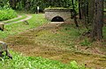
A few meters from the Röschenmundloch there is a Schütz ( Rainbachschütz ) in the artificial moat with a simple wooden building. On the table sheet no.116, sheet Lengefeld (1927), the natural watercourse bears the name Scheide-Bach .
From a fork in the Buschhausweg, at the site of the former Buschhaus, a path leads through the forest in a southerly direction to the upper Röschenmundloch. A few meters above the mouth there are two overgrown heaps. The artificial moat flowing in from Dörnthal is covered with concrete slabs. A forest stream crosses the artificial moat at the Schützenhaus. The Schütz drains into this stream, which flows off towards the village of Haselbach.
Lower rose mouth hole
The lower Röschenmundloch is located in the valley of the Biehlabach at about 545 m above sea level in a depression surrounded by trees and without a path connection. The structural design of the mouth hole has also been preserved in its original way. Blocks of gray gneiss, hewn right from the hammer, form the front and the curvature of the mouth hole with the inscribed keystone . It bears the inscription Quarter Crucis 1859 . A few meters west of the Röschenmundloch there is a small overgrown heap. The draining artificial moat is covered with concrete slabs.
gallery

Keystone at the upper mouth hole

Keystone at the lower mouth hole
Upper rose mouth hole and artificial moat


Web links
Individual evidence
- ^ A b c Otfried Wagenbreth , Eberhard Wächtler (ed.), A. Becke et al .: Der Freiberg mining. Technical monuments and history . German publishing house for basic industry , Leipzig, 1986, pp. 67, 248
- ^ Reichsamt für Landesaufnahme , Landesaufnahme Sachsen : Meßtischblatt 116. Lengefeld . Giesecke & Devrient , Leipzig, 1927