Haselstein (Berglen)
| Haselstein | ||
|---|---|---|
|
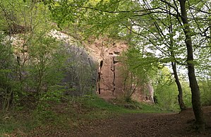
Abandoned quarry on the Haselberg with thick bench stone |
||
| height | 447.9 m above sea level NHN | |
| location | Winnenden ; Rems-Murr district | |
| Mountains | Buocher height ; Berglen | |
| Dominance | 1.8 km → Großer Rossberg | |
| Notch height | 20 m | |
| Coordinates | 48 ° 51 '26 " N , 9 ° 24' 7" E | |
|
|
||
The Haselstein is a 447.9 m above sea level. NHN high elevation in Berglen in the middle of Baden-Wuerttemberg and is less than a kilometer northwest of the town center of Winnenden - Breuningsweiler in western spur position right above the valley of the tip of Bach .
nature and landscape
location
The Haselstein, for its part, stands lower on a north-northwest foothills of the Buocher Höhe plateau , which is 519.6 m above sea level. NHN reaches its greatest height at the water tower of the eponymous and central place Buoch . In between, the cap of the Großer Rossberg rises 512 m above sea level. NHN on. The Haselstein is forested on its cap and on the northeast slope, while the lower slopes from southwest to west and north are covered by vineyards . There in the north they cover the even flatter summit of the Kleiner Rossberg ( 389 m above sea level ) on a much deeper foothill . Above on the south side of the Haselstein there is a disused quarry with a 50 meter long and up to 12 meter high quarry wall in the lower Stubenstandstein ( Löwenstein formation ). It served as a climbing garden until 2003, but was then closed due to falling rocks.
geology
The rocky summit of the Haselstein is formed by the Stubensandstein ( Löwenstein formation of the Middle Keuper ). The components of the parlor sandstone are firmly connected here , which is why stone blocks were once broken here. Entering the former quarry is dangerous because of falling rocks, which is why the “Geological Path” leads around it today. The concrete path roughly marks the border between the Upper Bunten Mergeln ( Mainhardt Formation of the Middle Keuper) with vineyards and the Stubensandstein above. While the soils of the multicolored marl are comparatively rich in nutrients, the weathered soils of the Stubensandstein are poor, which is why the forest here has been allowed to falter. Since man wanted to cultivate more and more, he pushed the forest back, but without success. What remained was a steppe-like strip of land between colored marls and parlor sandstone, which could not be used and thus developed naturally (today a natural monument).
Nature reserves
On the southern edge between forest and vineyards is the Haselstein natural monument with steppe heather and steppe heather bushes . The open location to the south allows a warmth-loving (xerothermal) plant community to develop, defined by Robert Gradmann as steppe heather. From the concrete path, the flowers can be admired from spring to autumn without having to enter the area.
See also
Individual evidence
- ↑ a b Map services of the Federal Agency for Nature Conservation ( information )
- ↑ Quarry after the biotope layer on: State Institute for the Environment Baden-Württemberg (LUBW) ( information )
literature
- Gudrun and Manfred Hennecke: The xerothermal plant locations in the Stubensandstein. In: NABU (ed.): The Obere Zipfelbachtal. Verlag M. Hennecke 2007, ISBN 978-3-927981-89-8 .

