
Heinrichsgraben
|
Heinrichsgraben
|
||
 Access to Heinrichsgraben |
||
| location | Undermassing | |
| surface | 6.4 ha | |
| Geographical location | 49 ° 5 ' N , 11 ° 19' E | |
|
||
| Sea level | from 454 m to 486 m | |
| Setup date | March 11, 1995 | |
| administration | District of Roth | |

The Heinrichsgraben is a small valley near Untermässing , a parish village in the Middle Franconian town of Greding in the district of Roth in Bavaria , through which the Schmiedackerbach flows.
location
The valley is located in the Altmühltal Nature Park , about one kilometer east of Untermässing between the Schleierberg and Katzenberg hills.
description
The protected area has a total area of 6.4 hectares and was designated as a protected landscape component in 1995 . It is also a geotope (576R003) and part of the eaves fauna-flora-habitat area of the southern Franconian Jura (FFH no. 6833-371; WDPA no. 555521725) and the nature reserve protection zone in the Altmühltal nature park (LSG no. LSG -00565.01; WDPA No. 396115).
In the upper area arises from the Malmuntergrenze the calcareous layer source of Schmiedacker brook which until the 19th century also named Heine Rick ditch wore. The high lime content of the water leads to tuff precipitation in the form of small mossy sinter basins and cascades over a length of about 100 m .
The Schmiedackerbach joins the Schwarzach after 1.5 kilometers at Untermässing . The partly gorge-like course of the stream is lined with a beech forest with characteristic ground vegetation. In spring there is a rich occurrence of Märzenbecher and wild garlic .
The valley is not developed for tourism and is difficult to access. This enabled the original character of the natural landscape to be preserved. Along the course of the stream there are numerous settlement sites from prehistoric times as well as a burial place, which can be assigned to the Latène and Urnfield periods . To the Roman period, the settlement was abandoned there because of the Limes was only two hours walk away to the south and the times were too restless. There are also no findings from the time of the Great Migration and only began sporadically again with the Carolingian period. The sites are protected as ground monuments.
Picture gallery
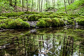
Moss-covered sinter basin
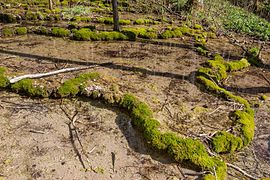
Sinter basin

a small "waterfall"

Blooming wild garlic

Wild garlic on the bank of the stream


Individual evidence
- ↑ Location of the Heinrichgraben in the Bavaria Atlas (accessed on August 12, 2016)
- ↑ Geotope: Sinter terraces in Heinrichsgraben SE von Untermässing (accessed on August 12, 2016)
- ↑ Ordinance, Heinrichsgraben (accessed on August 12, 2016)
- ↑ LfD list for Greding, pages 23 and 25 (.pdf)