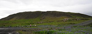
Helgafell (Mosfellsbær)
| Helgafell | ||
|---|---|---|
| height | 215 m | |
| location | In the southwest of Iceland | |
| Coordinates | 64 ° 10 ′ 25 ″ N , 21 ° 39 ′ 3 ″ W | |
|
|
||
| Type | Palagonite back | |
| rock | Palagonite | |
| Age of the rock | Pleistocene | |
The Helgafell (also Helgafell í Mosfellssveit ) (215 m) is a volcanic mountain in Iceland . It is located in the municipality of Mosfellsbær .
location
It is located about 5 km southeast of the city of Mosfellsbær in the catchment area of the Icelandic capital Reykjavík . Helgafell is located directly behind the Úlfarsfell mountain as seen from Hringvegur .
geology
The area with the mountains Mosfell and Helgafell as well as the nearby mountain range of the Esja has the oldest rocks around Reykjavík. They come from the Pliocene and Pleistocene .
Hiking on the mountain
From the Ása farm you can go up the mountain, but you should inquire beforehand whether the summit area is accessible (fence).

