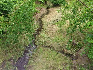
Herbigsbach
|
Herbigsbach Herbigsgraben |
||
|
The Herbigsbach in Schweinheim |
||
| Data | ||
| location |
Spessart
|
|
| River system | Rhine | |
| Drain over | Hensbach → Main → Rhine → North Sea | |
| source | in the See-Eck in Schweinheim 49 ° 56 ′ 59 ″ N , 9 ° 10 ′ 15 ″ E |
|
| Source height | 169 m above sea level NHN | |
| muzzle | in Schweinheim in den Hensbach Coordinates: 49 ° 57 '25 " N , 9 ° 9' 54" E 49 ° 57 '25 " N , 9 ° 9' 54" E |
|
| Mouth height | 151 m above sea level NHN | |
| Height difference | 18 m | |
| Bottom slope | 18 ‰ | |
| length | 980 m | |
| Catchment area | 1.6 km² | |
The Herbigsbach is a left tributary of the Hensbach in Aschaffenburg in Bavaria .
course
The Herbigsbach begins in Schweinheim in the See-Eck district at the football field at an altitude of approx. 169 m above sea level. NHN , leads through a pipe passage under the Reiterweg and then flows north-northwest to its final piping on the street An den Rosengärten , in which it then follows the Hensbach at approx. 151 m above sea level. NHN is fed.
See also
Web links
Commons : Herbigsbach - collection of images, videos and audio files
- The Herbisbach with its catchment area on the BayernAtlas
Individual evidence
- ↑ Background map : Position sheets 1: 25000 (1817-1841)
- ↑ a b c d BayernAtlas of the Bavarian State Government ( notes )
- ↑ Name after the original position sheet of the land survey in Bavaria: Hessenthal and surroundings in the year 1846, and the BayernAtlas in situation map scale.
