
Hilton of Cadboll Stone
The Hilton of Cadboll Stone , especially in older publications only Hilton Stone , is a Pictish stone monument that was found in the Hilton of Cadboll on the Scottish Tarbat Peninsula in Easter Ross , near a chapel. It shows a cross and pagan motifs. The larger top part of the stone is now in the National Museum of Scotland , the foot part in the Seaboard Memorial Hall in Balintore . A replica was set up at the original location in 2001. The chapel that used to be there has been on the list since 1962 as a ground monumentScheduled Monuments entered.

Location
The site of the stone is in the immediate vicinity of the remains of a chapel dedicated to the Virgin Mary, which was first mentioned in 1610, but is certainly older. Both are located within an area that was used as a cemetery in earlier times. The entire complex stands like a natural amphitheater, protected from three sides by slopes and only open to the sea, elevated above the Hilton of Cadboll, the northernmost of three fishing villages that have now grown together and are collectively referred to as Seaboard Villages . About three kilometers southwest, south of the southernmost of the three places, is the Shandwick Stone, a similar class II stone. In the immediate vicinity of St. Colman's Church in Portmahomack , which is almost ten kilometers away , excavations have uncovered a monastery from the 6th century , comparable stones were also found there. Another is in the town of Nigg, about eight kilometers southwest of the Hilton of Cadboll.
history
Comparisons of the artistic representations with those of other stones suggest a date of origin at the end of the 8th century. It is not known whether the stone was originally placed where it was found. It was there at least from the 12th century, as archaeological investigations established that the stone that had fallen over at that time had been put back up. Presumably during a storm in 1674 the stone fell over again and broke off in the lower part. The remaining top was reused two years later as a grave slab for a local dignitary named Alexander Duff and his three wives. The cross side of the stone was chiseled off and replaced with a contemporary inscription and a depiction of a coat of arms. For reasons not previously known, possibly because it was too heavy to be transported, it was not taken to Duff's grave in Fearn Abbey , three kilometers to the west , but remained on the spot.
The stone was rediscovered in June 1776. Charles Cordiner, a cleric from Banff who was also active as a landscape painter, illustrator and local historian, had also come to the Tarbat Peninsula on a tour of northern Scotland. The area's landowners from the Macleod clan of Cadboll Castle and Geanies Castle took Cordiner around and showed him various historical artifacts, including the tombstone. The stone, which was still headstone-side up, reminded him of the kind he had seen recently in Shandwick . The stone was then erected, whereupon Cordiner's assumption that Pictish drawings could also be seen on the stone was confirmed.
- Hilton of Cadboll Stone
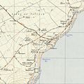
The Seaboard Villages with the stones from Shandwick (bottom) and Hilton of Cadboll (top right). Ordnance
Back of the replica set up at the site
Reconstructed cross side of the replica

Inscription from 1676

Engraving by Peter Mazell after a drawing by Charles Cordiner (1788)

Lithograph from 1856

View over the site

Detailed map of the site from 1906


In the same year Cordiner published his travelogue in the form of letters to his research colleague Thomas Pennant , briefly describing the stone. He referred to stories that the stones in the area had been set up as memories of victories against the armed forces of the Danes , but noted that the representations did not match the events at all. Rather, he suspected that the stones were supposed to commemorate the deeds of glory of those chiefs who were the first in the region to be converted to Christianity. Three years later there was also a translation into German. In a later work in 1788, Cordiner went into more detail on the stone. He placed it in the space between 1000 and 1200 and evaluated it undifferentiated as a memorial stone for people and events of that time. A drawing made by him and engraved by Peter Mazell was also included with the book.
Hugh Miller (1802-1856) offered only a brief description in 1835, but also referred to the presumed connection between the three stones and offered another legend. According to this, the Mormaer of Ross was married to a daughter of the Danish king. But he had proven to be a cruel husband, and so her father sent three of her brothers out with a fleet of ships to punish him. The ships went down or stranded on the coast and the three brothers drowned. Buried in three different places, her father later had the three monuments erected in these places in memory of his sons. Otherwise he speculated that the stones could mark the locations of chapels of the Culdeer .
The stone was mentioned again in 1856, at which time it was stored in a shed on the site. In addition, Andrew Gibb made another drawing which, in contrast to Cordiner's, also showed the damage. In the early 1860s, the Macleod family brought it to their castle in Invergordon , where it was installed as an ornament in the landscaped garden , along with another who had been found in Portmahomack . In 1921 the castle and properties were sold. The stone came to the British Museum , from where, after an outcry of public outrage, it was immediately transferred to the Scottish National Museum.
Excavations
In 1994 a local push was made to bring the stone back to its original location. Although this was not successful, it led to the first archaeological excavations in 1998. A sufficiently large potential for further investigations was found, and a proposal was made to set up a replica instead of the original. Two further excavations in the course of 2001 produced rich finds. So the lost base was rediscovered and excavated. In addition, over 10,000 stone fragments were found, of which around 1500 could be assigned to the original surface of the cross side. In addition, further information about the history of the stone, the chapel and the cemetery could be gathered.
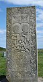
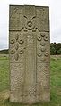
Also in 2001, as suggested, a replica of the stone made by the sculptor Barry Grove was erected. Originally only provided with the preserved side, the cross side, reconstructed on the basis of the excavation results, was later added to this.
description
The stone shows a Christian cross as well as Pictish symbolism and thus falls into category II within the framework of the scientific classification of these stones. It can thus, like all stones of this class, be addressed both as a Pictish symbol stone and as a cross stone . The stone is 140 centimeters wide. The top measures a height of 266 and a thickness of 4, the base a height of 85 and a thickness of 21 centimeters. The material, like that of the other stones, consists of old-red sandstone , a rock that is predominant in large parts of the area as the subsoil. It can be assumed that the material of all stones comes from the same quarry.
Both sides are richly decorated. Under the Pictish symbols of the crescent moon, the V-rod and the double disc there is a hunting scene. Inside is the extremely rare depiction of a galloping rider with a large ring brooch sitting in the side saddle . In front of her is a mirror and comb symbol. She seems to be holding something in her left arm. Two horsemen, two horn-blowing hunters on foot, dogs and deer make up the rest of the hunting scene. The lower part of the panel contains spiral patterns. The complicated frame has the tree of life with birds as a motif.
In addition to the central Christian symbol and ornamental decorations, three scenic representations can also be seen on the side of the cross. Two of them each show an angel and a human being, the third shows a man fighting a lion-like predator.
classification
When it was rediscovered in 1776, Charles Cordiner assigned the stone to a group due to its similarities to the stones from Nigg and Shandwick, which must be in some way related. The assumption, also made in the following years, that this was somehow related to unspecified Danes , was based on the legends mentioned. Indeed, in the early and high Middle Ages in the region there were frequent contacts and also armed conflicts with groups of Scandinavian origin, both with Danes in the true sense and with Vikings in general . The Orkneyinga saga tells of a battle which took place in the 11th century on Tarbat Ness, the northern tip of the Tarbat peninsula, and which at Thorfinn the Mighty inflicted a serious defeat on a Scottish king named Karl Hundason, possibly a nickname for Macbeth . Incidentally, the remains of an earthwork , formerly probably a fort with a dun , at Easter Rarichie, southwest of Shandwick, which until recently, also on topographical maps, were listed as Danish Fort , were actually assigned a comparable assignment the late iron and thus the Pict time are to be assigned.
These classifications are considered obsolete, also based on the results of the excavations in Portmahomack, which were started in 1991, intensified in 1994 and completed in 2007: the stones are clearly attributable to the Pict culture. Nevertheless, there is still no satisfactory reason for the importance of the stones themselves and for their noticeable accumulation in this region. Possibly they were part of a ritual landscape design, marked the outer boundaries of the holy monastery district, cemeteries or boat landing sites, served as landmarks , or told, quasi as stone hagiography , the life and revival story of saints in a place that was connected to their lives, because their hermitage was there. In that case it would be an event that occurred during a hunt. However, it cannot be ruled out that these are essentially secular, i.e. non-religious depictions of socially outstanding events, which were commissioned by people from the ruling class at the time, and in which the depiction of the cross and the rest of the Christian symbolism were only used as general sign of their faith functions. After all, both the erection of such stone monuments and the use of the typical Pictish symbols have a tradition that is older than the use of Christian motifs.
When looking at it, it should also be remembered that none of the stones is secured where it was originally placed. For the Hilton of Cadboll area, based on archival sources, a disappeared precursor settlement called Cadboll Fischer is assumed, which may have been around the chapel.
The excavation results of Portmahomack suggest the existence of a number of early medieval portages where boats were transported over short distances over land in order to shorten routes or to avoid dangerous stretches of coast. If the stones played a role in this or any other maritime context, it should be noted that the sea level was a few meters higher when they were erected, so the visibility from the seaside was significantly different from today.
Trivia
Part of the lower part of the symbolic engravings on the stone serves as the logo of the Glenmorangie whiskey distillery from Tain .
See also
literature
General overviews
- EJ Cowan, R. Andrew McDonald (Eds.): Alba. Celtic Scotland in the medieval era . Tuckwell, East Linton 2000, ISBN 1-86232-151-5 , pp. 76-87.
- Richard Feachem: Guide to prehistoric Scotland . 2nd edition. Batsford, London 1977, ISBN 0-7134-3264-0 .
Historical descriptions
- Charles Cordiner: Monument in Ross-Shire . In: Charles Cordiner: Remarkable ruins, and romantic prospects, of North Britain. With ancient monuments, and singular subjects of natural history . London, 1788. There is also a picture of the stone in it
- Charles Carter Petley: A short account of some carved stones in Ross-shire, accompanied with a series of outline engravings. Archaeologia Scotica, Volume IV, Edinburgh 1857, pp. 345-352. Digitized from the Archeology Data Service website, PDF file, 4MB, accessed September 20, 2012.
- Alexander Mackenzie: The Sculptured Stones of Ross and Cromarty. Published in chapters in: The Celtic Magazine: a Monthly Periodical, Inverness, in the following editions:
- Vol. VI, 1881: Chapter 1 , p. 476ff. (Oct. 1881)
- Vol. VII, 1882: Chapter 2 , pp. 1ff. (Nov. 1881)
- Chapter 3 , p. 76ff. (Dec. 1881)
- Chapter 4 , p. 121ff. (Jan 1882)
- Chapter 5 , p. 212ff. (March 1882)
- Chapter 6 p. 276ff. (April 1882)
- Chapter 7 , p. 309ff. (May 1882)
- Chapter 8 , p. 441ff (Aug. 1882)
- Chapter 9 , p. 537ff. (Oct. 1882)
- Vol. VIII, 1883: Chapter 10 p. 49ff. (Dec. 1882). The sequel announced there, at least in Celtic Magazine until it was discontinued in 1888, never happened. To the Hilton of Cadboll Stone in particular from chapter six.
- Cecil L. Curle: The chronology of the early christian monuments of Scotland. Proc Soc Antiq Scot, Vol. 74, 1939/40, Edinburgh 1940, pp. 60-116. Digitized version, PDF file, 12MB. Retrieved September 21, 2012. (English)
- Robert BK Stevenson: 'The Inchyra Stone and some other unpublished early Christian monuments'. Proc Soc Antiq Scot, Vol. 92, 1958/59, pp. 33ff. Edinburgh 1961. Digitized , PDF file, 4MB. Retrieved September 21, 2012. (English)
Current research results
- Justin Garner-Lahire: Geophysical and Topographical Survey. Hilton of Cadboll. Report of the results of the survey, May 1998. Digitized on the website of the Highland Historic Environment Record, PDF file, 3.9MB, accessed on September 29, 2012. (English)
- Martin Carver: Hilton of Cadboll. Archaeological Assessment and Project Design. Report, June 1998. Digitized on the website of the Highland Historic Environment Record, PDF file, 1.7MB, accessed on September 29, 2012. (English)
- Heather James, Isabel Henderson, Sally M. Foster and Sian Jones: A Fragmented Masterpiece: Recovering the biography of the Hilton of Cadboll Pictish cross-slab. Society of Antiquaries of Scotland, Edinburgh 2008. ISBN 978-0-9039-0342-4 Abstract , PDF file, 47kB, accessed September 20, 2012.
- Siân Jones: Heritage, Identity and Place: the biography of the Hilton of Cadboll Pictish cross-slab (2001-2007) . Brief report of the stone and excavation results on the website of the Archaeological Department of the University of Manchester.
- John Wood: The Hilton of Cadboll Stone. Importance and Potential. Digitized on the Highland Council website, PDF file, 2.2MB. Retrieved September 20, 2012.
Web links
- Entry on Hilton of Cadboll Stone in Canmore, Historic Environment Scotland database
- The Hilton of Cadboll Stone in the database Pictish symbol stones of the University of Strathclyde (English)
- List of historical monuments and historical and cultural website of the Highland Council , each with search function
- The Hilton of Cadboll Stone on the National Museum of Scotland website.
- Description of the excavation results with search function of over 800 significant artifacts found
- Website of the sculptor Barry Grove with a history of the replica
Individual evidence
- ↑ Scheduled Monument - Entry . In: Historic Scotland .
- ↑ Entry on Hilton of Cadboll Stone in Canmore, the database of Historic Environment Scotland (English)
- ↑ Petley, p. 348.
- ^ Charles Cordiner: Antiquities & scenery of the north of Scotland, in a series of letters to Thomas Pennant , London 1780. Description of the discovery on p. 65f.
- ↑ Karl Cordiner: Antiquities and Picturesque Descriptions of Northern Scotland. In: New collection of travelogues. Fifth part. Verlag Carl-Erst Bohn, Hamburg, 1783, p. 95ff.
- ^ Hugh Miller: Scenes and legends of the north of Scotland, or The traditional history of Cromarty . Edinburgh 1835, pp. 84ff. First edition and further editions of the complete work in the Open Library (English)
- ^ John Stuart: Sculptured stones of Scotland. Vol 1, Aberdeen 1856. Digitized version , from this the description and the drawing of the stone. Retrieved September 23, 2012. (English)
- ↑ Description of the stone Tarbat No. 1 on the website of the Highland Council (English). Retrieved September 19, 2012.
- ↑ Invergordon Castle on Invergordon website, accessed September 18, 2012 (English)
- ^ George Neilson: Donations to the Museum. Proc. Soc. Antiq. Soc., Vol. 56., 1921/22, Edinburgh 1922, pp. 60ff. Digitized version, PDF file, 1MB. Retrieved September 21, 2012. (English)
- ^ Martin Oswald Hugh Carver: Portmahomack. Monastery of the Picts. Edinburgh 2008, p. 182. ISBN 0-7486-2441-4 . Preview on Google Books, accessed September 24, 2012.
- ^ A b Martin Carver: An Iona of the East: the early medieval monastery at Portmahomack, Easter Ross, p. 25ff. In: Medieval Archeology 48, 2004, pp. 1–30. Digitized version, PDF file, 1.2MB, accessed on September 29, 2012. (English)
- ↑ Entry on Easter Rarichie in Canmore, the database of Historic Environment Scotland (English)
- ^ Carver, Portmahomack, p. 176. Preview
- ^ Carver, Portmahomack, pp. 187f. ISBN 0-7486-2441-4 .
- ^ Martin Carver: Tarbat Discovery Program, Bulletin 3, 1997 Regional Context on the York University website. Accessed September 30, 2012
Coordinates: 57 ° 46 ′ 1.9 ″ N , 3 ° 53 ′ 45.6 ″ W.