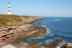
Tarbat Ness Lighthouse
| Tarbat Ness Lighthouse | ||
|---|---|---|
| Tarbat Ness lighthouse and headland | ||
| Place: | Tarbat peninsula | |
| Location: | Headland Tarbat Ness | |
| Geographical location: | 57 ° 51 '54 " N , 3 ° 46' 36" W | |
| Fire carrier height : | 41 | |
| Fire height : | 53 | |
|
|
||
| Identifier : | Blk. (4) w. every 30 s | |
| Operating mode: | electric | |
| Operating time: | since January 26, 1830 | |
The Tarbat Ness Lighthouse is the third tallest lighthouse in Scotland . It stands on the eastern coast facing the North Sea .
location
The lighthouse is located on the northern headland of the Tarbat Peninsula, called Tarbat Ness, which separates the Moray Firth to the east from the Dornoch Firth to the west . Politically, the area belongs to the Community Council Area of Tarbat, which is part of the Highland Council Area . The subsoil of the peninsula consists of old red sandstone . Since the east coast of the peninsula traces the course of the Great Glen Fault, small earthquakes occasionally occur.
history
The main reason for the construction of the lighthouse was a storm in November 1826, when a total of 26 boats sank in the Moray Firth. In the period that followed, there were calls for the access from the North Sea to the Moray Firth to be equipped with a lighthouse on both sides. Trinity House and the Caledonian Canal Commission, as the authorities responsible at the time, initially considered a lighthouse on the east side near Lossiemouth superfluous, the tower there on the Covesea Skerries could therefore only be started in 1845 and completed the following year.
On the west side there was more insight: the engineer Robert Stevenson , who had made a name for himself through the construction of several other lighthouses , was soon given the contract for the construction; the construction work was carried out by a company from Inverness . On January 26, 1830, the lighthouse at Tarbat Ness went into operation.
The tower, like all lighthouses in Scotland, is operated by the Northern Lighthouse Board . Since March 25, 1971 he is together with the former home of the lighthouse keeper and surrounding the plant enclosure, as Listed Building category A under monument protection .
Technical
With a height of 53 meters, it is the third tallest lighthouse in Scotland after Skerryvore and North Ronaldsay . There are 203 steps to the top. In 1892 the tower was completely restored and on this occasion received an improved optical system with a Fresnel lens developed by David Alan Stevenson , the constructor's grandson . In 1907, the original, petroleum-fired and four-burner argand lamp was replaced by a gas incandescent lamp with a 55 millimeter long mantle . In 1915 the tower was painted white and got the two red stripes. In 1985 it was automated and electrified, and the residential buildings were then sold. The optical system from 1892 is now in the National Maritime Museum in Greenwich .
Roman foundations

Occasionally it says that the tower is on a Roman foundation. However, this refers to a point a little to the north called Carn a 'Bhodaich , where there are a few stone remains of an object that has been assigned a corresponding origin. Originally it was more likely to have been a smaller beacon or a cairn . Its age is unclear, but it cannot be assigned to the Romans.
This assessment has its origin in The new statistical account of Scotland , a very detailed topographical standard work from the middle of the 19th century. There it is reported that there are remains of the foundation near the lighthouse that are said to be of Roman origin. The only report to date with a reference to structural remains of the Romans in this area came from a pastor and historian named John Grant. He had first published an article in 1798 in which he speculated that two cairns and the remains of some earthworks that he had discovered at Port A Chaistel, about three kilometers southwest of Tarbat Ness, looked as if they were the remains of a Roman camp and of a Praetorium . But no one was able to confirm this observation in the following period, attempts to find this camp again were unsuccessful. On older topographical maps, however, these assignments were entered on suspicion. To this day, however, there is no evidence of any Roman activities on the peninsula.
Web links
- Tarbat Ness Lighthouse at the Northern Lighthouse Board (English)
- Listed Building Entry . In: Historic Scotland .
- Tarbat Ness Lighthouse in the Historic Environment Record of the Highland Council (English)
- Tarbat Ness Lighthouse on a UK engineering website
Individual evidence
- ↑ Explanation of a photo from 1913 on the British Geological Survey website. Accessed October 1, 2012
- ^ Covesea Skerries Lighthouse on the Northern Lighthouse Board. Accessed October 1, 2012
- ↑ Entry on Carn A Bhodaich in the Historic Environment Record of the Highland Council, accessed on October 2, 2012 (English)
- ^ The new statistical account of Scotland, Vol. XIV , Pt. 2, Edinburgh and London 1845, p. 460. Available online in the Open Library by the side . (English)
- ^ John Grant, William Leslie: A Survey of the Province of Moray: Historical, Geographical, and Political , Aberdeen 1798, p. 56. Available online in the Open Library, right by the side . (English)
- ↑ Entry on Port A Chaistel in the Historic Environment Record of the Highland Council, accessed on October 2, 2012 (English)


