Rear Suwaldspitze
| Rear Suwaldspitze | ||
|---|---|---|
|
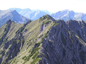
The Hintere Suwaldspitze from the east |
||
| height | 2159 m above sea level A. | |
| location | Tyrol , Austria | |
| Mountains | Lechtal Alps | |
| Dominance | 1.2 km → Steinmandlspitze | |
| Notch height | 90 m ↓ notch to Steinmandlspitze | |
| Coordinates | 47 ° 22 '32 " N , 10 ° 45' 16" E | |
|
|
||
| rock | Main dolomite | |
The rear Suwaldspitze is 2159 m above sea level. A. high mountain in the Lechtal Alps in Tyrol . The closest places are Miteregg in the west and Berwang in the north. The summit can only be reached without a path.
Surroundings
The Hintere Suwaldspitze is located in the Lorea group west of the Steinmandlspitze , with which it is connected by a Schrofengrat. In the north-west, the Vordere Suwaldspitze and the Hönigkamm, accessible by a marked path, join. The predominant main dolomite provides pine fields on the south side and broken fragments to the north.
Ascent
The two approaches to the Hintere Suwaldspitze are pathless and require surefootedness.
- From the Sonnbergsattel over the Vordere Suwaldspitze
From Berwang over the Hönigkamm or shorter through the Älpeletal to the Sonnbergsattel, there over the signposted path to the Vorderen Suwaldspitze (or past it) and further on without a path over the broad Schrofengrat to the summit. 2.5 hours from Berwang via Älpeletal
- From the Steinmandlspitze
From the Steinmandlspitze near the edge over the rugged southwest flank, immediately following a rocky upswing to the left, down to the lowest point. Continue over the mountain pine-covered ridge (I) or even deeper over path tracks in the southern flank back up to the summit. 45 min. From Steinmandlspitze
Literature and map
- Dieter Seibert: Lechtaler Alpen Alpin, Alpine Club Guide . Munich, Bergverlag Rudolf Rother, 2nd edition 2008. ISBN 978-3-7633-1268-9
- Alpine Club Map : Sheet 4/1 (1: 25,000). Wetterstein and Mieminger Mountains West. ISBN 978-3-928777-19-3

