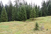
Hochälpelealpe
The Hochälpelealpe (also: Alpe Hochälpele or Hämmerles Älpele ) is located at about 1250 m above sea level. A. (main building) and is located in the area of the municipality of Schwarzenberg . It was and is an alp for grazing cattle and is a piece of land located at the same place (today known and named as: Hämmerles Älpele ).
The Alpe is owned by the Alpe Hochälpele agricultural community . The alp essentially consists of several alpine buildings that have been converted into residential houses or expanded.
Location and access
The Hochälpelealpe is located in the municipality of Schwarzenberg in the Bregenz Forest. There is no public access. The Alpe is about 2.7 km as the crow flies from Bödele , about 3 km from the center of Schwarzenberg and about 6 km as the crow flies from Dornbirn . The buildings are about 470 meters away from the municipality boundary of Dornbirn, which runs west of the alpine buildings. There are other Alps around the Hochälpelealpe, the most famous of which is the Gschwendtalpe in the Dornbirn municipality.
Children's rest home
After the Second World War until the 1980s, the Alpe was used as a children's rest home. Children of employees at FM Hämmerle were given the opportunity to send their children away for the summer completely free of charge . This was a social contribution from the Hämmerle company. Over the summer, boys and girls for two weeks were alternately housed, supervised and fed.
religion
On the alp, a few meters below the former alpine buildings, is the chapel of St. Benedict . It was used quite often in the past, and a mass was celebrated almost every weekend in the summer. After the older generation of the Hämmerle family died and the children's rest home was no longer in operation, the regular summer fairs were also given up.
Waters
The shallow pond on the alp has no inflow, but is formed by rainwater and surface water. The pond is about 80 meters away from the buildings of the Hochälpelealpe (south-southeast) and has the shape of an almost right-angled triangle and a side length of about (cathetus) 58 × 70 meters (approx. 2000 m²).
To the west and south of the alp rises at about 1300 m above sea level. A. from two sources the approximately 3.45 km long Steinrieslerbach and flows in a large curve to the east in the direction of Bersbuch and flows into the Bregenzer Ach (lot Loch , water kilometers Bregenzer Ach: 31.15). North of the alp rises at about 1235 m above sea level. A. the Dunklerbach, which flows in an easterly direction after about 1.5 km into the Steinrieslerbach.
hikes
Several easy hikes are possible from and to the Hochälpelealpe, for which you must be sure-footed and good footwear. The following tours / hikes to and from the Hochälpelealpe are very popular:
- Bödele ( 1139 m above sea level ): 1 hour walk ( Spechtweg ), 111 meters difference in altitude .
- Dornbirn ( 437 m above sea level ): 3 ¾ hours walking time, 813 meters difference in altitude.
- Dornbirn ( 437 m above sea level ): 2 ¾ hours of walking (Gschwendsattel- Kehlegg - Steinebach -Dornbirn), 813 meters difference in altitude.
- Schwarzenberg ( 696 m above sea level ): 2 hours walking time, 554 meters difference in altitude.
- Hochälpelekopf (Hochälpelehütte) ( 1463 m above sea level ): 40 minutes walk, 213 meters difference in altitude.
Closest hiking bases
There are several alpine huts and restaurants around the Hochälpelealpe within walking distance. The next hiking support points of the PES are the Freschenhaus (walking time 5 ½ hours) and the Lustenauer Hütte (walking time ¼ hour). The Bregenz Hut of Naturfreunde Österreich ( 1290 m above sea level ) on the Klausberg is 40 minutes' walk away. The Hochälpelehütte is also about 40 minutes' walk away.
Web links
Individual evidence
- ↑ Hochälpele No. 339 and No. 340
Coordinates: 47 ° 23 ′ 58.8 ″ N , 9 ° 49 ′ 10 ″ E


