Hochberg (Kaiserstuhl)
| Hochberg | ||
|---|---|---|
|
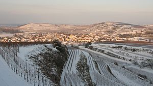
The Hochberg (right), above Jechtingen |
||
| height | 288.7 m above sea level NHN | |
| location | Baden-Wuerttemberg , Germany | |
| Mountains | Kaiserstuhl | |
| Coordinates | 48 ° 7 '28 " N , 7 ° 37' 18" E | |
|
|
||
| rock | Tephrite | |
The Hochberg ( 288.7 m above sea level ) is a small hill in the Kaiserstuhl low mountain range in the Emmendingen district in Baden-Württemberg .
geography
The Hochberg is located in the municipality of Sasbach am Kaiserstuhl in the Emmendingen district in Baden-Württemberg . The hill is located in the Jechtingen district between the Jechtingen district to the south-west and the Leiselheim district to the north-east .
On the northern side of the Hochberg is the nature reserve Hochberg , with an area of 0.7 hectares . Most of the approximately 93 hectares, however, are used for viticulture.
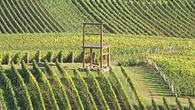
To the northwest lies the Eichert hill ( 267 m above sea level ). Below the Hochberg, on a farm road that runs between these hills and connects the districts, there is a small chapel ( location ) . Leiselheim's vineyard Gestühl is east of the hill . In the Middle Ages there was an important court site here, which gave the name to this low mountain range. An oversized chair made of wood indicates this historical place ( location ) .
hike
Some theme trails in the Kaiserstuhl lead over or along the Hochberg, such as B. the hoopoe path from Breisach to Sasbach, or the cherry tree path from Sasbach to Riegel .


