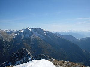
Hocheisspitze
| Hocheisspitze | ||
|---|---|---|
|
Hocheisspitze and Sittersbachscharte (left) |
||
| height | 2523 m above sea level NHN | |
| location | Bavaria , Germany ; Salzburg , Austria | |
| Mountains | Berchtesgaden Alps , Northern Limestone Alps | |
| Dominance | 3 km → Hochkalter | |
| Notch height | 410 m ↓ Sittersbachscharte | |
| Coordinates | 47 ° 32 '48 " N , 12 ° 50' 35" E | |
|
|
||
| First ascent | September 6, 1868, Hermann von Barth | |
| Normal way | Via Hocheiskar, unmarked ( I ) | |
The Hocheisspitze is 2523 m above sea level. NHN high mountain in the Berchtesgaden Alps , over which the border between Germany and Austria runs. It is also the highest mountain of the same name Hocheisgruppe that the Hochkalter belongs massif.
The Hocheisspitze was first verified to have been climbed by Hermann von Barth on September 6, 1868, but there are suspicions that the mountain was climbed earlier.
The unmarked normal route leads over the Hocheiskar (also Hintereis ) from the west to the summit ( difficulty I ). The summit can also be reached via the ridge between Kammerlinghorn ( 2483 m ) and Hocheisspitze. There are climbing difficulties from II-III to be mastered. In winter, mountaineers go on ski tours up the mountain.
literature
- Bernhard Kühnhauser: Alpine Club Guide Berchtesgaden Alps with Hochkönig . 20th edition. Bergverlag Rother , Munich 2011, ISBN 978-3-7633-1127-9 , pp. 490-492 .
- Kompass hiking, biking and ski touring map: Sheet 14 Berchtesgadener Land-Chiemgau Alps (1: 50,000). Compass maps, Innsbruck 2008, ISBN 978-3-85491-017-6
Individual evidence
- ^ Hermann von Barth: From the Northern Limestone Alps. 1874, Retrieved May 18, 2009 .

