Hochplatte (Tegernsee Mountains)
| High plate | ||
|---|---|---|
|
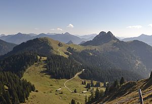
The Tegernsee plateau (left) from Schönberg . Right Roßstein and Buchstein . |
||
| height | 1592 m | |
| location | Bad Tölz-Wolfratshausen district , Bavaria , Germany | |
| Mountains | Bavarian Prealps | |
| Coordinates | 47 ° 38 '27 " N , 11 ° 40' 3" E | |
|
|
||
The high plate is a 1590.7 m above sea level. NHN high meadow summit, which is in front of the massif of Roßstein and Buchstein in the northwest and can be crossed by this on the way to the Seekarkreuz . The high plateau rises 9 km southwest of the Tegernsee in the area of Lenggries . It belongs to the Tegernsee Mountains and with them to the Bavarian Prealps .
Alpinism
The mountain, which offers good close-up views of Roßstein and Buchstein as well as the Kampen , can be reached from the Roßsteinalm over the ridge in a quarter of an hour.
literature
- W. and G. Zimmermann: Alpine Club Leader Bayerische Voralpen Ost , 2nd edition, Bergverlag Rudolf Rother, Munich 1980, ISBN 3-7633-1103-3
- Bavarian Land Surveying Office: Topographic map 1: 50,000 sheets L 8336 Miesbach

