Hochschulstrasse (Dresden)
| Hochschulstrasse | |
|---|---|
| Street in Dresden | |
| Basic data | |
| place | Dresden |
| District | Südvorstadt |
| Created | 1871 |
| Hist. Names | Sedanstrasse |
| Cross streets | Schnorrstrasse, Reichenbachstrasse , Lukasstrasse |
| Places | Friedrich-List-Platz , Fritz-Foerster-Platz |
| Numbering system | Orientation numbering |
| use | |
| User groups | Motor traffic , pedestrian traffic , bicycle traffic |
| Technical specifications | |
| Street length | approx. 800 meters |
The College Street is a 800-meter-long city road in Dresden (district Südvorstadt-Ost ). It connects Friedrich-List-Platz and Strehlener Straße not far from Dresden Central Station with Fritz-Foerster-Platz on the southern edge of the district. It is named after the former University of Transport (HfV).
Location, course and traffic
Hochschulstraße begins at Friedrich-List-Platz and leads straight and initially without any significant longitudinal incline towards the southwest. After about 300 meters, Schnorrstraße joins Hochschulstraße from the east. This is followed by the intersection with Reichenbachstrasse . The southern part of Hochschulstrasse that begins here is characterized by a steeper longitudinal slope. After crossing Lukasstraße, Hochschulstraße ends at Fritz-Foerster-Platz for motorized traffic in a dead end, but pedestrians and cyclists can get to Bergstraße , Zelleschem Weg or Nürnberger Straße via the square .
Double-sided parallel or perpendicular parking is possible on the entire Hochschulstraße. The house numbers follow the principle of orientation numbering . The street was not and is not served by local public transport.
history
The street was laid out in 1871 to further develop the American Quarter in the south suburb. It began at that time directly on Strehlener Strasse east of Bismarckplatz, today's Friedrich-List-Platz. In memory of the Franco-Prussian War and especially the Battle of Sedan in September 1870, the new road connection was given the name “Sedanstrasse”, while the Fritz-Foerster-Platz at the southern end was created as “Sedanplatz”.
Originally, Sedanstrasse south of Bismarckplatz had an intersection with Lindenaustrasse, and Schnorrstrasse also continued to the west in the direction of Reichsstrasse and Bergstrasse. These connections were only cut when the west side of the street was rebuilt in the GDR .
Well-known residents of Sedanstrasse were:
- Otto Beutler , later Lord Mayor of Dresden, at Sedanstrasse 4 between 1891 and 1894
- Oskar Wilhelm Schuster , royal Saxon officer, at Sedanstrasse 1
After the original development on Sedanstraße was destroyed by the bombing during the air raids on Dresden in February 1945, the establishment of the University of Transport (HfV), which was founded in 1952 and which is now namesake, began there in the 1950s. For the 10th anniversary of the university, it was given the nickname “ Friedrich List ” and part of the Hochschulstraße was given the name “Friedrich-List-Platz” together with the former Bismarckplatz and later Bayrischer Platz.
Between 2003 and 2005, the traffic routing at Fritz-Foerster-Platz was fundamentally changed, on the one hand to maintain an efficient motorway feeder along the Bergstrasse to the federal motorway 17 and, on the other hand, to make the outer city ring more efficient. During the construction work, the motorized traffic on Hochschulstraße (as well as George-Bähr-Straße) was decoupled from Fritz-Foerster-Platz and has since become a dead end for pedestrians and cyclists.
Development
In the American Quarter, a block perimeter development was initially built from predominantly four-storey representative apartment buildings, including along Sedanstrasse. Sedanstrasse 19–21 housed the 19th elementary school , and the Hotel Savoy-Albertshof was located at Sedanstrasse 7–9. To the south of Bismarckplatz, between Sedan and Reichsstrasse, there were also buildings of the Dresden University of Technology , the predecessor of the TU and HfV.
The air raids on Dresden almost completely destroyed the streetscape of Sedanstrasse. In the 1950s, reconstruction initially concentrated on the east side of the street. In April 1954, construction began on the central building and a seminar wing for the University of Transport, designed by Richard Paulick . As early as 1951, the foundation stone for University Building I , today's Gerhart-Potthoff-Bau , was laid on today's Fritz-Foerster-Platz . It was completed in 1956. At the intersection with Reichenbachstrasse, the cafeteria for the university was built from 1957 to 1959 . The Hochschulstraße connected all the important buildings of the HfV with one another.
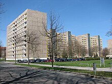
At the beginning of the 1980s, the area between Hochschul- and Juri-Gagarin-Straße (today Fritz-Löffler-Straße ) from Friedrich-List-Platz to Juri-Gagarin-Platz was built with ten-story apartment blocks. These were given the addresses Hochschulstrasse 2-44. At the intersection of Schnorrstrasse and Hochschulstrasse, a U-shaped six-storey apartment block was built between the cafeteria and seminar building of the HfV. The prefabricated buildings now belong to Vonovia SE and have largely not been renovated. On the area between Juri-Gagarin-Platz and Fritz-Foerster-Platz, three residential high-rise buildings for students (No. 46, 48 and 50) were built. The sixteen storeys were thoroughly renovated in 2006 and 2007. Hochschulstraße 50 is currently used as the international guest house of the Dresden Student Union .
On the east side of Hochschulstrasse there are smaller buildings between Reichenbachstrasse and Fritz-Foerster-Platz. The 117th “Ludwig Reichenbach” elementary school and its new gymnasium, which was completed in 2016, are located here, several tenement houses, a Protestant kindergarten opened in 2010 and the regional church office of the Evangelical Lutheran regional church of Saxony . This building, built in 1897, is the only pre-war structure on Hochschulstrasse.
Web links
- Hochschulstraße in the Stadtwiki Dresden
- Hochschulstraße on dresdner-stadtteile.de
Coordinates: 51 ° 2 ′ 4.2 ″ N , 13 ° 43 ′ 59.5 ″ E


