
Herrenbach flood retention basin
| Herrenbach flood retention basin | |||||||||
|---|---|---|---|---|---|---|---|---|---|
 |
|||||||||
|
|||||||||
|
|||||||||
| Coordinates | 48 ° 45 ′ 29 " N , 9 ° 35 ′ 10" E | ||||||||
| Data on the structure | |||||||||
| Construction time: | 1973-1976 / 79 | ||||||||
| Height above valley floor: | 22 m | ||||||||
| Height above foundation level : | 24 m | ||||||||
| Building volume: | 260 000 m³ | ||||||||
| Crown length: | 220 m | ||||||||
| Data on the reservoir | |||||||||
| Water surface | 16,704 6 ha | ||||||||
| Reservoir length | 1.3 km | ||||||||
| Reservoir width | 200 m | ||||||||
| Storage space | 1 925 000 m³ | ||||||||

The Herrenbach flood retention basin (also known as Herrenbachstausee ) crosses the border between the Rems-Murr district and the Göppingen district in Baden-Württemberg ( Germany ). It is located in the eastern part of the Schurwald near Adelberg and Schorndorf - Unterberken . Like the flood retention basins Christental and Simonsbachtal , it is operated by the Fils water association.
The flood retention basin was created in the 1970s after repeated floods in the Herrenbachtal. The 22 m high and 220 m long earth dam can hold back almost 2 million m³ of water. The reservoir is permanently dammed in part. The lake has a water depth of up to 18 meters and an area of around 17 hectares. It has a pre- dam, which is separated from the main dam by a front dam. The reservoir also serves to raise the low water level in the Fils .
Due to its beautiful landscape, the lake has become a popular local recreation area for hikers and walkers. The water area is not used for recreational purposes, only as fishing waters.
See also
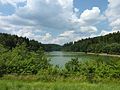
Herrenbachstausee in June 2014
