Hof (Ebrach)
|
court
Ebrach market
Coordinates: 49 ° 48 ′ 50 ″ N , 10 ° 27 ′ 52 ″ E
|
|
|---|---|
| Height : | 448 m above sea level NN |
| Residents : | 20th |
| Postal code : | 96157 |
| Area code : | 09553 |
|
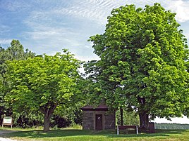
Hofer Chapel from 1838 (2013)
|
|
Hof is a district of Ebrach in the Upper Franconian district of Bamberg , Bavaria .
geography
Hof is located in the Steigerwald , about five kilometers north of Geiselwind at an altitude of 448 m above sea level. NN and embedded between:
West of Hof is the headwaters of the Reichen Ebrach .
history
The Bavarian original cadastre shows Hof in the 1810s as an anger village with six farms.
Attractions
At the northern entrance to the "Höfer Käppele" is from 1838, the under listed building stands. The former Hochstraße Frankfurt-Würzburg-Forchheim passed directly in front of Hof. At this highest point there was a watchtower more than 1200 years ago, from which one could overlook the Main crossing at Stadtschwarzach and see as far as Altenburg near Bamberg. The “Höfer Käppele” was built from the stones of this watchtower.
traffic
Hof can be reached via the state road St 2258 from the federal motorway 3 at junction 76. The public transport does not serve the place.
Individual evidence
- ↑ Hof bei BayernAtlas
- ↑ Hof on historical map at BayernAtlas Klassik
- ↑ LfD list for Ebrach (.pdf)
- ↑ courtyard. Retrieved December 29, 2017 .

