
High dock
| High dock | ||
|---|---|---|
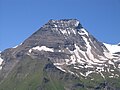
 High dock from the northeast |
||
| height | 3348 m above sea level A. | |
| location | Salzburg , Austria | |
| Mountains | Glockner Group , Hohe Tauern | |
| Dominance | 0.6 km → Great Bear Head | |
| Notch height | 114 m ↓ Dockscharte | |
| Coordinates | 47 ° 7 '51 " N , 12 ° 44' 27" E | |
|
||
| First ascent | about 1842–1845 G. Mayer ( Badhans ) on the occasion of a hunt | |

The Hohe Dock is located in the state of Salzburg in Austria and is at an altitude of 3348 m above sea level. A. one of the higher peaks of the Glockner group . With its distinctive trapezoidal shape, the mountain dominates the orographic left side of the Fuscher Ache valley and also the panorama on the northern ramp of the Grossglockner High Alpine Road .
The second peak, the southeast peak, reaches a height of 3268 m above sea level. A.
Ascent
The starting point is the end of the Fusch valley on the Großglocknerstrasse (Ferleiten). The summit can be reached via the Schwarzenberghütte ( 2267 m ) on a high alpine, marked trail.
Individual evidence
- ^ Willi End , Hubert Peterka : Alpine Club Leader Glockner and Granatspitz Group , Bergverlag Rudolf Rother , Munich 1990. ISBN 3-7633-1258-7
Web link
- Ascent to the Hohe Dock - (Czech / English)
gallery
Hohe Dock seen from the Grossglockner High Alpine Road
