Villeneuve (Aosta Valley)
| Villeneuve | ||
|---|---|---|

|
|
|
| Country | Italy | |
| region | Aosta Valley | |
| Coordinates | 45 ° 42 ' N , 7 ° 12' E | |
| surface | 8 km² | |
| Residents | 1,250 (Dec. 31, 2019) | |
| Population density | 156 inhabitants / km² | |
| Post Code | 11018 | |
| prefix | 0165 | |
| ISTAT number | 007074 | |
| Popular name | Villeneuvois or Villeneuvien (French) | |
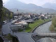
Villeneuve is an Italian commune in the autonomous region of Aosta Valley . The community has 1250 inhabitants (as of December 31, 2019), is located on the orographic right side of the Dora Baltea and has a size of 8 km².
The municipality belongs to the Unité des Communes valdôtaines Grand-Paradis and is its capital. The neighboring municipalities are Arvier , Aymavilles , Introd , Saint-Nicolas , Saint-Pierre and Valsavarenche .
The old Church of the Assumption of the Virgin Mary was mentioned in papal documents as early as 1184. The Tour Colin , a residential tower, dates from the 13th century.
Individual evidence
- ↑ Statistiche demografiche ISTAT. Monthly population statistics of the Istituto Nazionale di Statistica , as of December 31 of 2019.
Web links
Commons : Villeneuve (Aosta Valley) - Collection of images, videos and audio files


