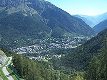
Courmayeur
| Courmayeur | ||
|---|---|---|

|
|
|
| Country | Italy | |
| region | Aosta Valley | |
| Coordinates | 45 ° 47 ' N , 6 ° 58' E | |
| height | 1224 m slm | |
| surface | 210 km² | |
| Residents | 2,730 (Dec. 31, 2019) | |
| Population density | 13 inhabitants / km² | |
| Factions | in French and patois : Dolonne (Dolénna), Entrèves (Éntréve), La Palud (La Palù), Villair Dessous (Lo Velé-Dézó), Villair Dessus (Lo Velé-Damón), Larzey (Lo Lazèi), Entrelevie (Éntrelvie) , La Villette (La Veletta), La Saxe (La Saha) | |
| Post Code | 11013 | |
| prefix | 0165 | |
| ISTAT number | 007022 | |
| Popular name | Cormaioresi (Italian) Courmayeurins (French) |
|
| Patron saint | St. Pantaleon | |
| Website | Courmayeur | |
Courmayeur is a town in the autonomous region of Aosta Valley in the Italian Alps . It has 2730 inhabitants (as of December 31, 2019) and an area of 210 km².
geography
Courmayeur is also called the secret capital of alpinists because of its location and is one of the oldest and most famous tourist resorts in the Alps. Shortly after Courmayeur, the entrance to the Mont Blanc tunnel begins .
Courmayeur is located ten kilometers southeast of Mont Blanc and gives the Mont Blanc de Courmayeur its name. The Aosta Valley begins here under the wall of Mont Blanc. At the foot of the mountain range are the first two side valleys of the Aosta Valley:
The Val Vény comes down from the southwest. At the upper end of the valley is the Combal basin, a silted-up lake which, together with Lake Miage ( 2020 m slm ), is one of the headwaters of the Dora Baltea . The Val Ferret comes down from the north-east under the peaks of Mont Dolent and the Grandes Jorasses and is navigable over a length of 14 km to the hamlet of Arnouvaz.
Both valleys can be completely hiked through on the Tour du Mont-Blanc circular route .
Courmayeur consists of the districts (in French and patois ): Dolonne (Dolénna), Entrèves (Éntréve), La Palud (La Palù), Villair Dessous (Lo Velé-Dézó), Villair Dessus (Lo Velé-Damón), Larzey (Lo Lazèi), Entrelevie (Éntrelvie), La Villette (La Veletta) and La Saxe (La Saha). The neighboring municipalities are Bourg-Saint-Maurice (France), Chamonix , France, La Salle , La Thuile , Les Contamines-Montjoie (France), Morgex , Orsières (Switzerland), Pré-Saint-Didier , Saint-Gervais-les-Bains (France) and Saint-Rhémy-en-Bosses .
From the Entrèves district (3 km north of Courmayeur) the Funivie Monte Bianco cable car leads to the Pointe Helbronner , from where you can take the Vallée Blanche small gondola lift in several sections over the entire Mont Blanc massif to Chamonix. The one and a half hour drive over the Glacier du Géant, the headwaters of the Mer de Glace , can be interrupted at several intermediate stations: Mont Fréty ( 2174 m ), Hotel Torino ( 3371 m ), Pointe Helbronner ( 3462 m ), Aiguille du Midi ( 3795 m) ) and Plan de l'Aiguille ( 2310 m ).
Between 1939 and 1946 the place had the Italianized name Cormaiore .
economy
The most important branch of the economy is tourism. Well-known personalities visited Courmayeur as early as the 18th and 19th centuries, for example Victor Emanuel II in 1850 .
Film and literature festival
The Courmayeur Noir In Festival has been held every December since 1991 .
Personalities
- Richard Pramotton (* 1964), ski racer
Web links
- Community website
- Courmayeur on the ETHorama platform
Individual evidence
- ↑ Statistiche demografiche ISTAT. Monthly population statistics of the Istituto Nazionale di Statistica , as of December 31 of 2019.
- ↑ Auguste Argentier: Courmayeur et Pré-St-Didier (val d'Aoste): leurs bains, leurs eaux & leurs environs . Damien Lyboz, Aosta 1864, p. 79.


