
Hopewell Cape
| Hopewell Cape | |||
|---|---|---|---|
| Location in New Brunswick | |||
|
|||
| State : |
|
||
| Province : | New Brunswick | ||
| County: | Albert County | ||
| Coordinates : | 45 ° 51 ′ N , 64 ° 34 ′ W | ||
| Time zone : | Atlantic Time ( UTC − 4 ) | ||
| Postal code : | E4H 3J8 | ||
| Area code : | +1 506 | ||

Hopewell Cape is a village in Albert County in the Canadian province of New Brunswick and the administrative seat ( Shiretown ) of the county. The population of Hopewell Cape is not recorded statistically, the parish Hopewell ( Hopewell Parish ) has 643 inhabitants (as of 2011). The first settlers in the region came from Germany via Pennsylvania , first named the place German Town and later called Hopewell in Pennsylvania after their place of origin .
geography
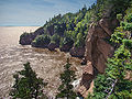
Hopewell Cape is near the mouth of the Petitcodiacriver on the coast of the Bay of Fundy . At a distance of around 40 kilometers, Moncton is located in the northwest. Hillsborough is ten kilometers to the north. New Brunswick Route 114 runs through Hopewell Cape . The place is famous for the Hopewell Rocks , jagged rock formations formed by tidal erosion and strong tidal fluctuations that are a tourist attraction for the region.
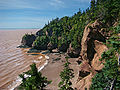
Hopewell Rocks at low tide
Hopewell Rocks at high tide

Hopewell Rocks at low tide

Hopewell Rocks at low tide


.jpg)
Hopewell Cape is home to the Albert County Museum , which provides an overview of Albert County's history and is affiliated with the RB Bennett Commemorial Center , which was named in honor of former Prime Minister of Canada Richard Bedford Bennett, who was originally from the region .
Individual evidence
- ↑ Statistics Canada - Census Hopewell, New Brunswick 2011
- ^ History
- ↑ Tide Preview
- ^ Albert County Museum
Web links
- hopewellcape - information page
- Regional Office Administration