Hornheimer bars
The Hornheimer Riegel is a terminal moraine in the south of Kiel . Its name goes back to three psychiatrists .
Origin, meaning and name
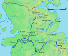
The last advance of the glacier at the site of the Kiel Fjord was Düsternbrook as lateral moraine and Hornsheimer bars are formed as the terminal moraine. It "seals" the formerly uniform meltwater valley in two sections, the fjord in the north and the Eider in the south. Five kilometers from the Baltic Sea, it forces the Eider flowing north to the west ( North Sea-Baltic Sea watershed ). She still has 180 kilometers to go to the North Sea . The ridge of the ridge drops off quite steeply and is bordered to the west by the (old) Hamburger Chaussee and the Petersburger Weg. A military training area was created in the western part when the town grew too close to the parade ground on Kuhberg. In the 1930s, a railway settlement was built on the eastern slope on the Hamburg-Altona-Kiel railway line . It reached to the east side of Schwanebeckstrasse. The 70-hectare Vieburger wood with the Kiel telecommunications tower is located above Bundesstraße 4 .
The Hornheimer Riegel owes its name to the Hornheim . In 1845 Peter Willers Jessen named his new private clinic after two Berlin psychiatrists.
Web links
Individual evidence
- ↑ Formation of the Kiel Fjord and its moraines (study project 2007/08 of the CAU) ( Memento of the original from September 21, 2013 in the Internet Archive ) Info: The archive link has been inserted automatically and has not yet been checked. Please check the original and archive link according to the instructions and then remove this notice. (PDF; 1.8 MB)
- ^ Kiel Lexicon , Wachholtz Verlag
- ↑ In the Kiel sailors' uprising , the parade ground served as a meeting place for the sailors
Coordinates: 54 ° 17 ′ 51 ″ N , 10 ° 7 ′ 25 ″ E

