
Hosur
| Hosur | |||
|---|---|---|---|
|
|||
| State : |
|
||
| State : | Tamil Nadu | ||
| District : | Krishnagiri | ||
| Location : | 12 ° 44 ′ N , 77 ° 50 ′ E | ||
| Height : | 879 m | ||
| Residents : | 116,821 (2011) | ||
| Postal code : | 635109 | ||
| Website : | http://municipality.tn.gov.in/hosur/ | ||
 |
|||

The south Indian city of Hosur ( Tamil ஓசூர் ) is located in the Krishnagiri district in the state of Tamil Nadu with around 120,000 inhabitants. It is best known as an industrial settlement. Tamil, English, Telugu and Kannada are spoken .
history
Hosur belonged to the Kingdom of Mysore until 1799 , when it became part of British India through military conquest .
traffic
Road connections exist via the National Highway AH43 (formerly NH7 ) in the direction of Bangalore , Chennai , Kanyakumari , Palakkad and Salem . Hosur is on the Bengaluru - Dharmapuri - Salem line of the South Western Railway . There are flight connections from the Hosur Aerodrome (1994). The nearest airport with international connections is Kempegowda International Airport (Bengaluru Int.), About 80 km away .
Attractions
- Hogenakkal Falls in Dharmapuri
- Rajaji Memorial (birthplace of C. Rajagopalachari )
- Sri Chandrachoodeshwara Temple
- Ecological Park & Walkers Lane on Ramanaicken Lake
- Hosur Fort
photos

New bus station
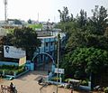
City administration

View of Hosur from the Chandra Choodeswarar Temple

Park entrance on Ramanakayan Lake

A processional float


Historical pictures by the military painter James Hunter (1755–1792; Royal Artillery):
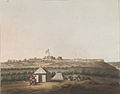
North West View of Osar by James Hunter (d.1792) (colored in 1804)

South East View of Osar by James Hunter (d.1792) (colored in 1804)
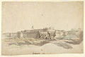
The fort of Hosur, 1792, from the south-west with breached wall and Union flag flying by James Hunter (d.1792)


Web links
- Hosur Municipality - City Council (Engl.)
- On the history of Hosur, page of the Digital South Asia Library (English ed. Sir William Stevenson Meyer et al. New edition, Oxford, Clarendon Press, 1908–1931 [v. 1, 1909])