
Hrusevytsia
| Hrusevytsia | |||
| Грузевиця | |||

|
|
||
| Basic data | |||
|---|---|---|---|
| Oblast : | Khmelnytskyi Oblast | ||
| Rajon : | Khmelnitsky district | ||
| Height : | 287 m | ||
| Area : | 10 km² | ||
| Residents : | 2,036 (2001) | ||
| Population density : | 204 inhabitants per km² | ||
| Postcodes : | 31317 | ||
| Area code : | +380 382 | ||
| Geographic location : | 49 ° 29 ' N , 26 ° 49' E | ||
| KOATUU : | 6825082201 | ||
| Administrative structure : | 1 village | ||
| Address: | вул. Жовтнева 13 31310 смт. Чорний Острів |
||
| Website : | Official website of the municipality | ||
| Statistical information | |||
|
|||


Hrusewyzja ( Ukrainian Грузевиця ; Russian Грузевица Grusewiza ) is a village in the center of the Ukrainian Oblast Khmelnytskyi with about 2000 inhabitants (2001).
The village, first mentioned in writing in 1784, has administratively belonged to the territorial municipality of Chornyj Ostriw ( Чорноострівська селищна об'єднана територіальна громада ) since 2015 and was previously an independent district council .
The village is located in the historical region of Podolia in the north-west of Khmelnytskyi district at an altitude of 287 m on the bank of the southern bow . Hrusewyzja at territorial road T-23-11 , over which the community center Chorny Ostriw 8 kilometers north-west direction and the Rajon- and Oblastzentrum Chmelnyzkyj 14 km can be reached in the southeastern direction. The village has a train station on the Krasne – Odessa railway line .

Village church

Southern Bow floodplains. Nature reserve near Hrusewytsja

Memorial to those who fell in the Great Patriotic War
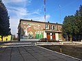
House of Culture


Web links
- Page to the village on ok.ru (Ukrainian)
Individual evidence
- ↑ a b local website on the official website of the Verkhovna Rada ; accessed on June 7, 2020 (Ukrainian)
- ↑ Chornyj Ostriv community on gromada.info ; accessed on June 7, 2020 (Ukrainian)
- ↑ website of the municipal council on rada.info ; accessed on June 7, 2020 (Ukrainian)