Hugoton
| Hugoton | ||
|---|---|---|
|
Location in Kansas
|
||
| Basic data | ||
| Foundation : | 1885 | |
| State : | United States | |
| State : | Kansas | |
| County : | Stevens County | |
| Coordinates : | 37 ° 11 ′ N , 101 ° 21 ′ W | |
| Time zone : | Central ( UTC − 6 / −5 ) | |
| Residents : | 3,831 (as of 2017) | |
| Population density : | 832.8 inhabitants per km 2 | |
| Area : | 4.6 km 2 (approx. 2 mi 2 ) | |
| Height : | 948 m | |
| Postal code : | 67951 | |
| Area code : | +1 620 | |
| FIPS : | 20-33425 | |
| GNIS ID : | 0470626 | |
| Website : | cityofhugoton.com | |
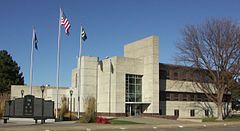
Hugoton is a small town in Stevens County in the US state of Kansas and its administrative seat. At the 2010 census it had 3,904 inhabitants.
geography
The city is located in the extreme southwest of Kansas in the High Plains , about 360 kilometers southwest of Wichita and approximately 630 km southwest of Kansas City . The Hugoton gas field was discovered near the city in 1922 , the largest gas field in the United States, which extends over the states of Kansas , Oklahoma and Texas .
education
There are three public schools in Hugoton; an elementary school , which runs until the 6th grade, a middle school for grades 7 and 8, a high school for grades 9-12 and a "learning academy". There is also a private Christian school for grades 1-8.
Personalities
- Billy Drago (1945–2019), actor
Web links
Commons : Hugoton, Kansas - Collection of images, videos, and audio files
proof
- ↑ American FactFinder - Hugoton City, Kansas , accessed October 24, 2018
- ^ Kansas Geological Survey - The Hugoton Project , accessed October 24, 2018
- ^ Hugoton Public Schools , accessed October 24, 2016

