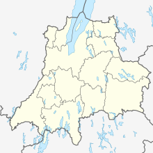
Hultagård
| Hultagård | ||||
|
||||
| State : | Sweden | |||
| Province (län): | Jönköpings län | |||
| Historical Province (landskap): | Småland | |||
| Municipality : | Sävsjö | |||
| Coordinates : | 57 ° 23 ' N , 14 ° 48' E | |||
| SCB code : | S1709 | |||
| Status: | Småort | |||
| Residents : | 81 (December 31, 2015) | |||
| Area : | 0.31 km² | |||
| Population density : | 261 inhabitants / km² | |||
Hultagård is a village ( småort ) in the Swedish municipality of Sävsjö .
The place is east of Sävsjö . To the north of the village, road 127 runs from Sävsjö to Vetlanda . The road to Skepperstad runs south through Hultagård . South of the village is the village of Burseryd , north of Hulta . Borrsjön lake extends to the south of Hultagård.
The place gained importance when the Sävsjö – Målilla railway was built in the 19th century and a train station was built in the area of Hultagård. At the beginning of the 20th century, Hultagård was a separate municipality, which also included Skepperstad. In 1952, Hultagård became part of the municipality of Sävsjö. In the 1950s the place had public facilities such as a school and post office. There were also several shops. In 1961, passenger traffic on the railway line was initially discontinued, followed by freight traffic in 1973. With the decreasing importance of the place, the shops and public facilities also disappeared. However, some businesses remained.
Galleri Webb is in Hultagård . Arts and crafts are sold in the gallery. It opened in September 2003.
The population of Hultagård rose from 67 (as of 2000) to 81 in 2015.
Individual evidence
- ↑ a b Statistiska centralbyrån : Småorter 2015, byggnader, areal, överlapp tatorter, coordinater (Excel file)
