Hungerberg (Marienmünster)
| Hungerberg | ||
|---|---|---|
|
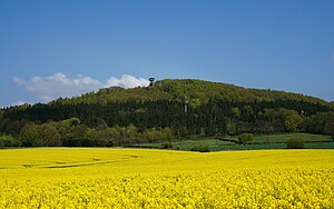
Hungerberg with observation tower |
||
| height | 324.1 m above sea level NHN | |
| location | District of Höxter , North Rhine-Westphalia , Germany | |
| Mountains | Weserbergland | |
| Coordinates | 51 ° 49 '47 " N , 9 ° 13' 31" E | |
|
|
||
| particularities | Hunger Mountain Tower ( AT ) | |
The Hungerberg is 324.1 m above sea level. NHN high mountain in the Weserbergland in the city of Marienmünster . There is a chapel and an observation tower at the top .
Geographical location
The Hungerberg is about a kilometer north of Vörden , a district of Marienmünster in the North Rhine-Westphalian district of Höxter . At the northern foot of the mountain the federal highway 239 runs , at the southeast foot there is a holiday village.
Name and early history
The origin of the name Hungerberg is not clear: The term “hunger” in the sense of needing to eat was probably not used in the region back then. For this meaning it should have been Schmachtberg. A name for the Hungarians who set up camp on the mountain is probably conceivable. But it is also not clear whether the name comes from this.
Little is known about the early history of the Hungerberg. However, the discovery of a flint blade under a root near the Hungerberg Chapel shows that people visited the place thousands of years ago. Whether the Hungerberg served as a refuge or a religious meeting place in pre-Christian times, like other mountain tops, has not yet been proven archaeologically.
Facilities on the mountain
Holy House
In 1779 the citizens of Vörden, Johannes and Anna-Maria Masolle, built a small chapel on the Hungerberg, which was also called the Holy House . It stood at the end of a row of seven wooden wayside shrines to commemorate the Passion of Christ in Jerusalem. Since at least this year, the procession to the summit of the Hungerberg has always taken place on Peter and Paul, during which the holy house has been used to display the consecrated gifts since 1779.
Optical telegraph
The Prussian telegraph's office building No. 30 had stood on the Hungerberg since 1833 . This telegraph was part of the Prussian optical telegraph line Berlin – Koblenz . The telegraph station consisted of a residential building in which the upper telegraph operator and the sub-telegraph operator lived with their families. It had a tower with two floors, in which the upper and the lower duty room were. There was no pump or well; Presumably rainwater or, in the case of drought, water either from below the old sports field at the foot of the mountain or from the small spring on the northern flank of the mountain.
Hungerberg Chapel
After the telegraph operation had ceased, the station building was auctioned for demolition. The property itself went to the municipality of Vörden. The Hungerberg Chapel was built on the foundation walls of the service building in 1851 , inaugurated in 1852 and which the painful mother has as patronage. Today the monument is a neo-Gothic brick building with buttresses. Your pyramid roof has a bell tower and is covered with sandstone slabs. A two-winged iron grille stands at the ogival entrance. The interior is baroque in nature. It includes u. a. two side altar-like wooden fixtures with a color scheme to match the high altar, painting with half-length figure of St. Kilian in a medallion frame and a wooden relief, painted in color, with a full-length representation of Saints Peter and Paul. The ascent to the mountain begins about 1 km from the chapel, where the 14 stations of the Hungerberg Cross Trail, laid out in 1857, extend.
Hunger Mountain Tower
On the mountain, in the immediate vicinity of the chapel, there is the Hunger Mountain Tower, a wooden observation and museum tower built in 2008 with a 21-meter-high observation platform . In the past there was a viewing platform below the chapel, which has now disappeared, with a view of the Vördener Feldmark and the Steinheimer Börde. At the same time, the tower, 25 meters high without a mast, with its display boards and the symbolic signal mast in position "H" for Hungerberg is supposed to keep the memory of the telegraph station alive. As early as 1943, the then mayor Elsing could no longer give any information about a station on the mountain. The city archive does not have any documents on this.
literature
- Wilhelm Hagemann: Vörden. History of a farming town in eastern Westphalia. Bonifatius-Verlag, Paderborn 2008, ISBN 978-3-89710-424-2 .
Web links
- Poem by Heinz Mönkemeyer : The Hungerberg's Chapel ...
Individual evidence
- ↑ Map services of the Federal Agency for Nature Conservation ( information )
- ↑ Hagemann: Vörden. History of a farming town in eastern Westphalia.
- ↑ a b Information board "The Hungerberg near Vörden - an old place of Christian piety" near the chapel on the Hungerberg.
- ^ Church chronicle St. Kilian Vörden, entry 1779.
- ^ Parish of St. Kilian Vörden: Festschrift for the 200th return of the Hungerberg procession on June 24, 1978.
- ↑ a b c d The Hungerberg near Vörden. The story of a hilltop. Festschrift for the inauguration of the observation and museum tower and to commemorate the construction of the optical telegraph line from Berlin to Koblenz 175 years ago. Heimat- und Kulturverein Marienmünster (ed.), 2008.
- ↑ Optical telegraph in Prussia: Station 30: Marienmünster-Vörden Hungerberg .
- ↑ a b Part A of the monuments list of the city of Marienmünster, entry as monument number V8 from May 6, 1994.
- ↑ Hunger Mountain Tower on the website of the Teutoburg Forest / Eggegebirge Nature Park Association

