Hutchinson River
|
Hutchinson River (Aquacanounck, Aqueanounck, Aqueanouncke, East Chester Creek, Eastchester Creek, Eastchester River, Hutchins Creek, Hutchinson Creek, Hutchinson's Brook, Hutchinson's River, Hutchinsons River) |
||
|
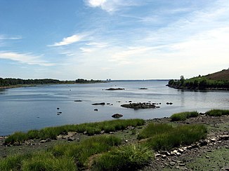
Mouth of the Hutchinson River into Eastchester Bay in Pelham Bay Park |
||
| Data | ||
| Water code | US : 953545 | |
| location | New York , (USA) | |
| origin | Located in Scarsdale , New York 40 ° 59 ′ 14 " N , 73 ° 47 ′ 8" W. |
|
| Source height | 66 m | |
| muzzle |
Eastchester Bay , New York Coordinates: 40 ° 51 ′ 14 " N , 73 ° 48 ′ 28" W 40 ° 51 ′ 14 " N , 73 ° 48 ′ 28" W. |
|
| Mouth height | 0 m | |
| Height difference | 66 m | |
| Bottom slope | 4.1 ‰ | |
| length | 16 km | |
| Catchment area | 36,260 km² | |
| Big cities | New York City | |
| Small towns | Scarsdale , New Rochelle , Eastchester , Mount Vernon , Pelham | |
| Navigable | on the lower 4.8 km | |
The Hutchinson River is a 16 km long river in the US state of New York in the northeastern United States .
River course
The river has its source in the area of the town of Scarsdale . From there it flows 16 km in a predominantly southerly direction until it flows into Eastchester Bay of Long Island Sound in the northeast of the Bronx in New York City . The Hutchinson River forms the border between the cities of New Rochelle and Eastchester as well as Mount Vernon and Pelham . The river is an estuary for about half its length .
history
The name of the river goes back to Anne Hutchinson , who settled on the lower reaches of the river in 1642. Her place of residence was on the opposite side of the river from what is now the Co-op City .
From 1924 to 1941, was Parkway -Straßenverbindung Hutchinson River Parkway built, but parallel, in part, a greater distance to the river from New York City to Greenwich (Connecticut) leads.
shipping
The Hutchinson River is navigable about 3 miles upstream into the Mount Vernon metropolitan area .
bridges
The navigable part of the Hutchinson River is spanned by six bridges. Starting from the mouth, these are:
- the Pelham Bridge ( Moving Bridge ), a road bridge,
- the Pelham Bay Bridge (Moving Bridge) on the Northeast Corridor Rail Link ,
- the Hutchinson River Parkway Bridge (Moving Bridge),
- the bridge of the New England Thruway ( I-95 ),
- the Eastchester Brigde ( Boston Post Road ),
- the Fulton Ave Bridge (Moving Bridge)
Individual evidence
- ^ Hutchinson River. Geographic Names Information System , accessed September 9, 2018 .
