Iñapari
| Iñapari | ||
|---|---|---|
|
|
||
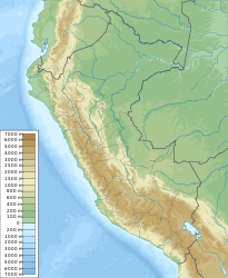
| Coordinates | 10 ° 57 ′ S , 69 ° 35 ′ W | |
| Basic data | ||
| Country | Peru | |
| Madre de Dios | ||
| province | Tahuamanu | |
| ISO 3166-2 | PE-MDD | |
| District | Iñapari | |
| height | 234 m | |
| Residents | 1890 (2017) | |
Iñapari is a town in the South American Andean state of Peru .
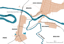
Iñapari is the administrative seat of the province of Tahuamanu , one of three provinces in the Madre de Dios region , and is located in the border triangle Peru - Bolivia - Brazil . The village is connected to Brazil and the Brazilian neighboring city of Assis Brasil via the Puente de la Integración de Acre , a binational bridge over the Río Acre . Iñapari has a population of 1,890 according to the 2017 census and has grown significantly over the past decade since the opening of the Transoceánica , which connects São Paulo with Lima .
Individual evidence
Web links
Commons : Iñapari - collection of images, videos and audio files

