Iberger ball
| Iberger ball | ||
|---|---|---|
|
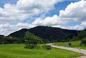
The Iberger Kugel seen from the east |
||
| height | 1049.4 m above sea level NHN | |
| location | Baden-Württemberg , Bavaria , Germany | |
| Mountains | Allgäu Alps | |
| Coordinates | 47 ° 38 '21 " N , 10 ° 4' 38" E | |
|
|
||
The Iberger Kugel (not to be confused with the nearby Iberg ; approx. 960 m above sea level ) is 1049.4 m above sea level. NHN high north-eastern secondary summit of the Riedholzer Kugel mountain ( 1066 m above sea level ) in the northern end of the Allgäu Alps in Baden-Württemberg and Bavaria ; its summit is in Württemberg .
Geographical location
The Iberger Kugel rises in the southeast corner of the district of Ravensburg (Baden-Württemberg), which separates the western district of Lindau (Lake Constance) from the eastern district of Oberallgäu (both in Bavaria). It is located around 6.5 km southeast of the city of Isny . About 2.4 km northwest is Maierhöfen (district of Lindau), about 1.1 km east of Seltmans and about 1.3 km east-southeast of Sibratshofen (both to Weitnau in the district of Oberallgäu).
About 150 m north-northwest of the summit lies at 1012.7 m above sea level. NHN is a trigonometric point .
Iberger Kugel transmitter
The Iberger Kugel transmitter is located on the Iberger Kugel , from which Radio 7 is broadcast on 105.0 MHz and Radio Marine Radio on 103.9 MHz.
gallery
The Iberger Kugel seen from the eastern Weitnau valley
Individual evidence
- ↑ a b Map services of the Federal Agency for Nature Conservation ( information )
- ↑ Bavaria Atlas of the Bavarian State Government ( notes )


