
Inverbervie
|
Inverbervie Scottish Gaelic Inbhir Biorbhaidh |
|||
|---|---|---|---|
 |
|||
| Coordinates | 56 ° 51 ′ N , 2 ° 17 ′ W | ||
|
|||
| Residents | 2233 2011 census | ||
| administration | |||
| Post town | MONTROSE | ||
| ZIP code section | DD10 | ||
| prefix | 01561 | ||
| Part of the country | Scotland | ||
| Council area | Aberdeenshire | ||
| British Parliament | West Aberdeenshire and Kincardine | ||
| Scottish Parliament | Angus North and Mearns | ||

Inverbervie ( Gaelic : Inbhir Biorbhaidh or Inbhir Beirbhe ), locally and historically also called Bervie after the associated Parish , is a village in the Scottish Council Area Aberdeenshire . It is located on the North Sea coast at the mouth of the Bervie Water about 16 km northeast of Montrose and about twelve kilometers southwest of Stonehaven . In 2011 Inverbervie had 2233 inhabitants.
history
In 1362 the Scottish King David II raised Inverbervie to the status of Royal Burgh . The reason for this was probably the fact that the king was shipwrecked at Inverbervie on his return from exile in France and set foot on Scottish soil for the first time at this point. In 1788, Scotland's first flax mill was built in Inverbervie and the village developed into a center of the textile and food industries. In 1969 a statue was unveiled in honor of the city's most famous son, Hercules Linton , who built the famous Cutty Sark tea clipper .
traffic
The A92 trunk road ( Perth –Stonehaven) runs through Inverbervie and connects the village to the road network. A few kilometers west of the proceeds Edinburgh to Fraserburgh leading A90 . The nearest train stations are in Laurencekirk and Stonehaven. They are served on the Glasgow to Aberdeen Line and the Edinburgh to Aberdeen Line of the First ScotRail .

Inverbervie Church
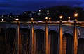
Bridge over the Bervie Water

Cutty Sark statue in Inverbervie


