Iowa Highway 21

|
|
|---|---|
| map | |

|
|
| Basic data | |
| Overall length: | 97.19 mi / 156.41 km |
| Opening: | October 1934 |
| Starting point: |
|
| End point: |
|
| Counties: |
Keokuk County Poweshiek County Iowa County Benton County Tama County Black Hawk County |
| Important cities: |
Delta What Cheer Deep River Guernsey Belle Plaine Dysart Waterloo |
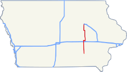
The Iowa Highway 21 (short IA 21 ) is a state highway that runs from north to south in central Iowa . It has a length of 97.19 mi (156.41 km).
Iowa Highway 21 has its southern end point on Iowa Highway 149 near Hedrick and its northern end point at a freeway intersection with US Highway 20 in Waterloo .
Route description
Iowa Highway 21 begins one mile west of Hedrick and continues north through Delta before crossing Iowa Highway 22 west of Thornburg . He continues north to Deep River , where he intersects Iowa Highway 85 . After driving Guernsey behind him, he first crosses Interstate 80 to then meet US Highway 6 . He shared a route with him for a while; it changes direction and is now heading east. Eventually he turns north near Victor . Then he crosses Iowa Highway 212 before passing through Belle Plaine and then crossing US Highway 30 . It continues north to Dysart , where it faces west and shares a route with Iowa Highway 8 . Then he continues north and ends on US Highway 20 on the southern city limits of Waterloo.
history
The current version of Iowa Highway 21 is the second occurrence of that number in the state. The first version went from Ida Grove to the Minnesota border and was eventually replaced by US Highway 59 . The current Iowa Highway 21 was built in October 1934 and went from Victor to Dysart. It was expanded south in 1939 from Victor to Iowa Highway 9 and in 1969 north from Dysart to US Highway 20 in Waterloo. In 1980 it was expanded south from Iowa Highway 92 to Iowa Highway 149.
See also
Web links
- Iowa Highways (English)