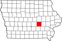
Poweshiek County
![The Poweshiek County Courthouse in Montezuma, listed in the NRHP since 1981 [1]](https://upload.wikimedia.org/wikipedia/commons/thumb/b/bc/Poweshiek_County_IA_Courthouse.jpg/298px-Poweshiek_County_IA_Courthouse.jpg) The Poweshiek County Courthouse in Montezuma , listed on the NRHP since 1981 |
|
| administration | |
|---|---|
| US state : | Iowa |
| Administrative headquarters : | Montezuma |
| Address of the administrative headquarters: |
County Courthouse P.O. Box 57 Montezuma, IA 50171-0057 |
| Foundation : | 1843 |
| Made up from: | Indian country |
| Area code : | 001 641 |
| Demographics | |
| Residents : | 18,914 (2010) |
| Population density : | 12.5 inhabitants / km 2 |
| geography | |
| Total area : | 1518 km² |
| Water surface : | 3 km² |
| map | |
| Website : poweshiekcounty.org | |
The Poweshiek County is a county in the US -amerikanischen State Iowa . In 2010 , the county had 18,914 residents and a population density of 12.5 people per square kilometer. By 2015 the population had decreased to 18,550. The county seat is Montezuma , named after the Aztec ruler of Mexico .
geography
The county is located in southeastern Iowa and has an area of 1,518 square kilometers, of which three square kilometers are water.
From west to east it is traversed by Big Bear Creek , which is part of the Mississippi catchment area via the Iowa River .
Poweshiek County borders on the following neighboring counties:
| Marshall County | Tama County | Benton County |
| Jasper County |

|
Iowa County |
| Mahaska County | Keokuk County |
history
Poweshiek County was formed in 1843 from territory that was designated as free - but actually populated by Indians . It was named after Poweshiek , a chief of the Fox - Indians .
structure
Poweshiek County is divided into 16 townships :
|
|
The city of Grinnell does not belong to any township.
population
| Population development | |||
|---|---|---|---|
| Census | Residents | ± in% | |
| 1850 | 615 | - | |
| 1860 | 5668 | 821.6% | |
| 1870 | 15,581 | 174.9% | |
| 1880 | 18,936 | 21.5% | |
| 1890 | 18,354 | -3.1% | |
| 1900 | 19,414 | 5.8% | |
| 1910 | 19,589 | 0.9% | |
| 1920 | 19,910 | 1.6% | |
| 1930 | 18,727 | -5.9% | |
| 1940 | 18,758 | 0.2% | |
| 1950 | 19,344 | 3.1% | |
| 1960 | 19,300 | -0.2% | |
| 1970 | 18.803 | -2.6% | |
| 1980 | 19.306 | 2.7% | |
| 1990 | 19,033 | -1.4% | |
| 2000 | 18,815 | -1.1% | |
| 2010 | 18,914 | 0.5% | |
| 2015 estimate | 18,550 | -1.9% | |
| Before 1900 1900–1990 2000–2015 | |||
According to the 2010 census , Poweshiek County had 18,914 people in 7,650 households. The population density was 12.5 inhabitants per square kilometer. Statistically, 2.23 people lived in each of the 7650 households.
The racial the population was composed of 94.9 percent white, 1.2 percent African American, 0.2 percent Native American, 1.4 percent Asian and other ethnic groups; 1.4 percent were descended from two or more races. Hispanic or Latino of any race was 2.4 percent of the population.
20.9 percent of the population were under 18 years old, 60.7 percent were between 18 and 64 and 18.4 percent were 65 years or older. 51.1 percent of the population was female.
The median income for a household was 50,998 USD . The per capita income was $ 25,218. 11.2 percent of the population lived below the poverty line.
Localities
Incorporated cities and non-incorporated census-designated places (CDP) :
| place | Residents 2010 |
Residents 2015 |
Type |
|---|---|---|---|
| Grinnell | 9218 | 9141 | City |
| Brooklyn | 1468 | 1420 | City |
| Montezuma | 1462 | 1411 | City |
| Victor 1 | 893 | 888 | City |
| Holiday Lake | 433 | 340 | CDP |
| Malcom | 287 | 278 | City |
| Deep river | 279 | 270 | City |
| Barnes City 2 | 176 | 174 | City |
| Searsboro | 148 | 143 | City |
| Hartwick | 86 | 83 | City |
| guernsey | 63 | 61 | City |
Unincorporated communities not recorded separately from the census :
See also
- Poweshiek County Courthouse
- List of entries on the National Register of Historic Places in Poweshiek County
Individual evidence
- ↑ Extract from the National Register of Historic Places - No. 81000266. Retrieved January 2, 2017.
- ↑ GNIS-ID: 465267. Retrieved on February 22, 2011 (English).
- ↑ a b c U.S. Census Bureau, State & County QuickFacts - Poweshiek County, IA. Retrieved January 2, 2017
- ^ National Association of Counties.Retrieved February 2, 2011.
- ↑ Missouri Census Data Center. Retrieved January 2, 2017.
- ^ US Census Bureau - Census of Population and Housing.Retrieved March 15, 2011
- ^ Extract from Census.gov.Retrieved February 16, 2011
- ↑ a b American Fact Finder. Retrieved January 2, 2017
Web links
Coordinates: 41 ° 41 ′ N , 92 ° 32 ′ W
