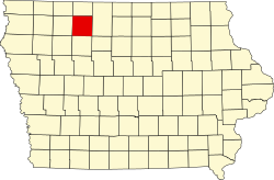
Palo Alto County
 The Palo Alto County Courthouse in Emmetsburg |
|
| administration | |
|---|---|
| US state : | Iowa |
| Administrative headquarters : | Emmetsburg |
| Address of the administrative headquarters: |
County Courthouse 1010 Broadway Street Emmetsburg, IA 50536-2483 |
| Foundation : | January 15, 1851 |
| Made up from: | Kossuth County |
| Area code : | 001 712 |
| Demographics | |
| Residents : | 9421 (2010) |
| Population density : | 6.4 inhabitants / km 2 |
| geography | |
| Total area : | 1475 km² |
| Water surface : | 14 km² |
| map | |
| Website : www.paloaltocountyiowa.com | |
The Palo Alto County is a county in the US -amerikanischen State Iowa . At the 2010 census , the county had 9,421 people and a population density of 6.4 people per square kilometer. By 2016 the population decreased to 9047. The administrative seat ( county seat ) is Emmetsburg , named after Robert Emmet , an Irish patriot.
geography
The county is located in northwest Iowa and is traversed by the western headwaters ( West Fork ) of the Des Moines River .
In the middle of the county is the Five Island Lake , a natural lake about three square kilometers in size.
To the north, the Minnesota border is about 35 km away. Palo Alto County covers an area of 1,475 square kilometers, of which 14 square kilometers are water. It borders on the following neighboring counties:
| Dickinson County | Emmet County | |
| Clay County |

|
Kossuth County |
| Buena Vista County | Pocahontas County | Humboldt County |
history
| Population development | |||
|---|---|---|---|
| Census | Residents | ± in% | |
| 1860 | 132 | - | |
| 1870 | 1336 | 912.1% | |
| 1880 | 4131 | 209.2% | |
| 1890 | 9318 | 125.6% | |
| 1900 | 14,354 | 54% | |
| 1910 | 13,845 | -3.5% | |
| 1920 | 15,486 | 11.9% | |
| 1930 | 15,398 | -0.6% | |
| 1940 | 16,170 | 5% | |
| 1950 | 15,891 | -1.7% | |
| 1960 | 14,736 | -7.3% | |
| 1970 | 13,289 | -9.8% | |
| 1980 | 12,721 | -4.3% | |
| 1990 | 10,669 | -16.1% | |
| 2000 | 10.147 | -4.9% | |
| 2010 | 9421 | -7.2% | |
| 2016 estimate | 9047 | -4% | |
| Before 1900 1900–1990 2000–2016 | |||
Palo Alto County was formed on January 15, 1851 from former parts of Kossuth County. It was named after a battlefield in the Mexican-American War .
A separate administration was set up in 1858 in a small town called Paoli. In 1859 the administration and court building was opened.
In 1874 it was decided to create a new city. A year later, the new town of Emmetsburg was ready to take up county administration. In 1880 a new courthouse was built. This was rebuilt several times and the prison was moved to another building. The last extension was completed by 1977.
4 of the county's structures and sites are on the National Register of Historic Places .
population
As of the 2010 census , there were 9,421 people in 3,979 households in Palo Alto County. The population density was 6.4 people per square kilometer. Statistically, 2.24 people lived in each of the 3,979 households.
The racial the population was composed of 97.8 percent white, 0.5 percent African American, 0.2 percent Native American, 0.3 percent Asian and other ethnic groups; 0.8 percent were descended from two or more races. Hispanic or Latino of any race was 1.6 percent of the population.
22.0 percent of the population were under 18 years old, 56.7 percent were between 18 and 64 and 21.3 percent were 65 years or older. 50.3 percent of the population was female.
The median income for a household was 42,800 USD . The per capita income was $ 23,071. 10.6 percent of the population lived below the poverty line.
Localities
Incorporated cities :
| place | Residents 2010 |
Residents 2016 |
|---|---|---|
| Emmetsburg | 3904 | 3758 |
| Graettinger | 844 | 806 |
| West Bend 1 | 785 | 755 |
| Ruthven | 737 | 700 |
| Mallard | 274 | 266 |
| Ayrshire | 143 | 139 |
| Cylinder | 88 | 85 |
| Curlew | 58 | 56 |
| Rodman | 45 | 44 |
Unincorporated communities not recorded separately from the census :
1 - partially in Kossuth County
structure
The Palo Alto County is divided into 16 townships :
|
|
See also
- Palo Alto County Courthouse
- List of entries on the National Register of Historic Places in Palo Alto County
Individual evidence
- ↑ GNIS-ID: 465262. Retrieved on February 22, 2011 (English).
- ↑ a b c U.S. Census Bureau, State & County QuickFacts - Palo Alto County, IA. Retrieved October 3, 2017
- ^ National Association of Counties. Retrieved January 29, 2012
- ^ US Census Bureau - Census of Population and Housing.Retrieved March 15, 2011
- ^ Extract from Census.gov.Retrieved February 16, 2011
- ^ E-ReferenceDesk Palo Alto County, Iowa - County History.Retrieved March 1, 2011
- ↑ Search mask database in the National Register Information System. National Park Service , accessed August 26, 2017.
- ↑ a b American Fact Finder. Retrieved October 3, 2017
- ^ Census Data Center - Iowa. Retrieved October 3, 2017
Web links
Coordinates: 43 ° 5 ′ N , 94 ° 41 ′ W


