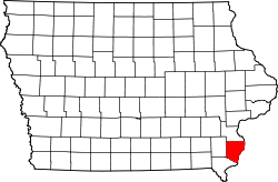
Des Moines County
![The Des Moines County Courthouse in Burlington, listed on the NRHP since 2003 [1]](https://upload.wikimedia.org/wikipedia/commons/thumb/7/7b/Des_Moines_County_Court_House_-_Burlington_Iowa.jpg/298px-Des_Moines_County_Court_House_-_Burlington_Iowa.jpg) The Des Moines County Courthouse in Burlington, listed on the NRHP since 2003 |
|
| administration | |
|---|---|
| US state : | Iowa |
| Administrative headquarters : | Burlington |
| Address of the administrative headquarters: |
County Courthouse 513 North Main Street Burlington, IA 52601-5220 |
| Foundation : | October 1, 1934 |
| Made up from: | Michigan Territory |
| Area code : | 001 319 |
| Demographics | |
| Residents : | 40,325 (2010) |
| Population density : | 37.4 inhabitants / km 2 |
| geography | |
| Total area : | 1113 km² |
| Water surface : | 35 km² |
| map | |
| Website : www.co.des-moines.ia.us | |
The Des Moines County is a county in the US -amerikanischen State Iowa . In 2010 the county had 40,325 residents and a population density of 37.4 people per square kilometer. By 2013 the population increased to 40,480. The county seat is Burlington .
geography
The county is located in southeast Iowa and borders Illinois to the east , from which it is separated by the Mississippi . The Iowa- Missouri border runs approximately 60 km south and southeast. The county has an area of 1113 square kilometers, of which 35 square kilometers are water.
In the south, Des Moines County is bounded by the Skunk River up to its confluence with the Mississippi . The Flint Creek flows through the center of the county and also flows into the Mississippi at Burlington.
The following neighboring counties border Des Moines County:
| Louisa County |
Mercer County, Illinois |
|
| Henry County |

|
Henderson County (Illinois) |
| Lee County |
history
Des Moines County was formed on October 1, 1834. It was named after the Des Moines River , to the left bank of which the county stretched at that time.
population
| Population development | |||
|---|---|---|---|
| Census | Residents | ± in% | |
| 1840 | 5577 | - | |
| 1850 | 12,988 | 132.9% | |
| 1860 | 19,611 | 51% | |
| 1870 | 27,256 | 39% | |
| 1880 | 33,099 | 21.4% | |
| 1890 | 35,324 | 6.7% | |
| 1900 | 35,989 | 1.9% | |
| 1910 | 36,145 | 0.4% | |
| 1920 | 35,520 | -1.7% | |
| 1930 | 38.162 | 7.4% | |
| 1940 | 36,804 | -3.6% | |
| 1950 | 42,056 | 14.3% | |
| 1960 | 44,605 | 6.1% | |
| 1970 | 46,982 | 5.3% | |
| 1980 | 46.203 | -1.7% | |
| 1990 | 42,614 | -7.8% | |
| 2000 | 42,351 | -0.6% | |
| 2010 | 40,325 | -4.8% | |
| 2013 estimate | 40,480 | 0.4% | |
| Before 1900 1900–1990 2000 2010–2013 | |||
As of the 2010 census , Des Moines County had 40,325 people in 17,126 households. The population density was 37.4 inhabitants per square kilometer. Statistically, 2.35 people lived in the 17,126 households.
The racial the population was composed of 91.0 percent white, 5.1 percent African American, 0.2 percent Native American, 0.7 percent Asian and other ethnic groups; 2.3 percent were descended from two or more races. Hispanic or Latino of any race was 2.6 percent of the population regardless of ethnicity.
23.2 percent of the population were under 18 years old, 59.2 percent were between 18 and 64 and 17.6 percent were 65 years or older. 51.4 percent of the population was female.
The median income for a household was 41,273 USD . The per capita income was $ 23,114. 12.8 percent of the population lived below the poverty line.
Des Moines County localities
structure
Des Moines County is divided into 12 townships :
|
|
The cities of Burlington , Danville , Mediapolis , Middletown and West Burlington do not belong to any township.
See also
Individual evidence
- ↑ Landmark Hunter - Des Moines County Court House (Ref. 03000817) Retrieved December 26, 2014.
- ↑ Des Moines County ( English ) In: Geographic Names Information System . United States Geological Survey . Retrieved January 14, 2011.
- ↑ a b c U.S. Census Bureau, State & County QuickFacts - Des Moines County, IA ( July 9, 2011 memento on WebCite ) Retrieved December 26, 2014.
- ↑ a b National Association of Counties.Retrieved December 26, 2014.
- ^ US Census Bureau - Census of Population and Housing.Retrieved March 15, 2011.
- ^ Extract from Census.gov.Retrieved February 16, 2011.
- ↑ 2010 US Census Iowa Township and Other Subdivision Population. (PDF) Retrieved July 23, 2019 .
Web links
Coordinates: 40 ° 56 ′ N , 91 ° 11 ′ W


