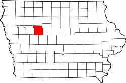
Calhoun County, Iowa
![The Calhoun County Courthouse in Rockwell City, listed on the NRHP since 1981 [1]](https://upload.wikimedia.org/wikipedia/commons/thumb/f/f9/Calhoun_County_IA_Courthouse.jpg/298px-Calhoun_County_IA_Courthouse.jpg) The Calhoun County Courthouse in Rockwell City, listed on the NRHP since 1981 |
|
| administration | |
|---|---|
| US state : | Iowa |
| Administrative headquarters : | Rockwell City |
| Address of the administrative headquarters: |
County Courthouse 416 4th Street, Suite 1 Rockwell City, IA 50579-1428 |
| Foundation : | January 15, 1851 |
| Made up from: | Original County |
| Area code : | 001 712 |
| Demographics | |
| Residents : | 9670 (2010) |
| Population density : | 6.6 inhabitants / km 2 |
| geography | |
| Total area : | 1482 km² |
| Water surface : | 6 km² |
| map | |
| Website : www.calhouncountyiowa.com | |
The Calhoun County is a county in the US -amerikanischen State Iowa . In 2010 , the county had 9,670 people and a population density of 9.6 people per square kilometer. By 2013 the population increased to 9,926. The county seat is Rockwell City .
geography
The county is located northwest of the geographic center of Iowa and covers an area of 1,482 square kilometers, of which six square kilometers are water.
The south-west of the county is from the North Raccoon River flows through which over the Raccoon River and the Des Moines River to the basin of the Mississippi belongs.
The following neighboring counties border Calhoun County:
| Buena Vista County | Pocahontas County | |
| Sac County |

|
Webster County |
| Carroll County Greene County |
history
The Calhoun County was formed on January 15, 1851 from designated as free - but in fact settled by Indians - territory. It was named in 1853 after John C. Calhoun (1782–1850), the 7th Vice President of the United States.
| Population development | |||
|---|---|---|---|
| Census | Residents | ± in% | |
| 1860 | 147 | - | |
| 1870 | 1602 | 989.8% | |
| 1880 | 5595 | 249.3% | |
| 1890 | 13,107 | 134.3% | |
| 1900 | 18,569 | 41.7% | |
| 1910 | 17,090 | -8th % | |
| 1920 | 17,783 | 4.1% | |
| 1930 | 17.605 | -1 % | |
| 1940 | 17,584 | -0.1% | |
| 1950 | 16,925 | -3.7% | |
| 1960 | 15,923 | -5.9% | |
| 1970 | 14,287 | -10.3% | |
| 1980 | 13,542 | -5.2% | |
| 1990 | 11,508 | -15% | |
| 2000 | 11,115 | -3.4% | |
| 2010 | 9670 | -13% | |
| 2013 estimate | 9926 | 2.6% | |
| Before 1900 1900–1990 2000 2010–2013 | |||
When the tracks of the Illinois Central Railroad were also laid through this county in 1870 , the seat of the county administration was moved from Lake City to Rockwell City. The first train reached Rockwell City on August 7, 1882 and the population doubled in the same year. The first wooden courthouse burned down completely in 1884 and the administration was moved to a nearby hotel. The courthouse, which is still used today, was built in 1913.
From 1890 onwards, drains were built across the county on a large scale to drain the land and preserve more good farmland. In the years that followed, this became the right solution, and the county became one of the most agriculturally productive and prosperous in the state.
population
As of the 2010 census , there were 9,670 people in 4,293 households in Calhoun County. The population density was 9.6 inhabitants per square kilometer. Statistically, 2.15 people lived in each of the 4,293 households.
The racial the population was composed of 98.5 percent white, 0.2 percent African American, 0.2 percent Native American, 0.2 percent Asian and other ethnic groups; 0.6 percent were descended from two or more races. Hispanic or Latino of any race was 0.9 percent of the population.
21.2 percent of the population were under 18 years old, 55.1 percent were between 18 and 64 and 23.7 percent were 65 years or older. 51.4 percent of the population was female.
The median income for a household was 44,833 USD . The per capita income was $ 22,195. 11.2 percent of the population lived below the poverty line.
Localities in Calhoun County
1 - partly in Webster County
2 - partly in Sac County
structure
Calhoun County is divided into 16 townships :
|
|
The city of Lake City does not belong to any township.
See also
Individual evidence
- ↑ Listing on the National Register of Historic Places - No. 81000227. Accessed March 21, 2018
- ↑ Calhoun County ( English ) In: Geographic Names Information System . United States Geological Survey . Retrieved February 23, 2011.
- ↑ a b c U.S. Census Bureau, State & County QuickFacts - Calhoun County, IA. Retrieved November 21, 2014
- ↑ a b National Association of Counties.Retrieved November 21, 2014
- ^ US Census Bureau - Census of Population and Housing.Retrieved March 15, 2011
- ^ Extract from Census.gov.Retrieved February 16, 2011
- ↑ 2010 US Census Iowa Township and Other Subdivision Population. Retrieved July 23, 2019 .
Web links
Coordinates: 42 ° 23 ′ N , 94 ° 39 ′ W

