
Crawford County, Iowa
![The Crawford County Courthouse in Denison, listed on the NRHP since 1981 [1]](https://de.wikipedia.org/wiki/Datei:Crawford_courthouse_denison_iowa.jpg) The Crawford County Courthouse in Denison, listed on the NRHP since 1981 |
|
| administration | |
|---|---|
| US state : | Iowa |
| Administrative headquarters : | Denison |
| Address of the administrative headquarters: |
County Courthouse 1202 Broadway Denison, IA 51442-0423 |
| Foundation : | January 1, 1851 |
| Made up from: | Shelby County |
| Area code : | 001 712 |
| Demographics | |
| Residents : | 17.096 (2010) |
| Population density : | 9.2 inhabitants / km 2 |
| geography | |
| Total area : | 1852 km² |
| Water surface : | 2 km² |
| map | |
 |
|
| Website : www.crawfordcounty.org | |
The Crawford County is a county in the US -amerikanischen State Iowa . In 2010 , the county had 17,096 residents and a population density of 9.2 people per square kilometer. By 2013, the population had increased to 17,434. The county seat is Denison .
geography
The county is located almost in the far west of Iowa and is about 25 miles to the west from the Missouri , which forms the Iowa border with Nebraska . The county covers an area of 1,852 square kilometers, of which two square kilometers are water.
Crawford County is traversed from northeast to southwest by the Boyer River , a left tributary of the Missouri. The western source of the Nishnabotna River, which also drains into the Missouri, rises in the southeast of the county.

The Boyer River near Denison
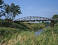
The Nishnabotna River Bridge , listed in the NRHP with the number 99000309


The following neighboring counties border Crawford County:
| Woodbury County | Ida County | Sac County |
| Monona County |
.svg)
|
Carroll County |
| Harrison County | Shelby County | Audubon County |
history

| Population development | |||
|---|---|---|---|
| Census | Residents | ± in% | |
| 1860 | 383 | - | |
| 1870 | 2530 | 560.6% | |
| 1880 | 12,413 | 390.6% | |
| 1890 | 18,894 | 52.2% | |
| 1900 | 21,685 | 14.8% | |
| 1910 | 20,041 | -7.6% | |
| 1920 | 20,614 | 2.9% | |
| 1930 | 21,028 | 2% | |
| 1940 | 20,538 | -2.3% | |
| 1950 | 19,741 | -3.9% | |
| 1960 | 18,569 | -5.9% | |
| 1970 | 18,780 | 1.1% | |
| 1980 | 18,935 | 0.8% | |
| 1990 | 16,775 | -11.4% | |
| 2000 | 16,942 | 1 % | |
| 2010 | 17.096 | 0.9% | |
| 2013 estimate | 17,434 | 2% | |
| Before 1900 1900–1990 2000 2010–2013 | |||
Crawford County was formed on January 1, 1851 from former parts of Shelby County.
It was named after the former finance and war minister and presidential candidate William Harris Crawford (1772-1834).
The first county courthouse was built in 1857. Construction of the second began on November 10, 1903. The first floor was built from sandstone, the second and third floor from white stones. A thorough restoration was carried out in 1976,
population
According to the 2010 census , Crawford County had 17,096 people in 6,537 households. The population density was 9.2 inhabitants per square kilometer. Statistically, 2.41 people lived in each of the 6537 households.
The racial the population was composed of 82.9 percent white, 1.2 percent African American, 0.3 percent Native American, 0.6 percent Asian and other ethnic groups; 1.6 percent were descended from two or more races. Hispanic or Latino of any race was 24.2 percent of the population.
26.4 percent of the population were under 18 years old, 57.3 percent were between 18 and 64 and 16.3 percent were 65 years or older. 49.2 percent of the population was female.
The median income for a household was 42,916 USD . The per capita income was $ 19,988. 12.3 percent of the population lived below the poverty line.
Crawford County localities
structure
Crawford County is divided into 20 townships :
|
|
See also
Individual evidence
- ↑ Extract from the National Register of Historic Places - No. 81000232. Retrieved March 12, 2012
- ↑ Crawford County ( English ) In: Geographic Names Information System . United States Geological Survey . Retrieved January 14, 2011.
- ↑ a b c U.S. Census Bureau, State & County QuickFacts - Crawford County, IA. Retrieved December 11, 2014
- ↑ a b National Association of Counties.Retrieved December 11, 2014
- ↑ Extract from the National Register of Historic Places.Retrieved November 17, 2011
- ^ US Census Bureau - Census of Population and Housing.Retrieved March 15, 2011
- ^ Extract from Census.gov.Retrieved February 16, 2011
- ↑ 2010 US Census Iowa Township and Other Subdivision Population. Retrieved July 23, 2019 .
Web links
List of counties in Iowa
Adair |
Adams |
Allamakee |
Appanoosis |
Audubon |
Benton |
Black Hawk |
Boone |
Bremer |
Buchanan |
Buena Vista |
Butler |
Calhoun |
Carroll |
Cass |
Cedar |
Cerro Gordo |
Cherokee |
Chickasaw |
Clarke |
Clay |
Clayton |
Clinton |
Crawford |
Dallas |
Davis |
Decatur |
Delaware |
Des Moines |
Dickinson |
Dubuque |
Emmet |
Fayette |
Floyd |
Franklin |
Fremont |
Greene |
Grundy |
Guthrie |
Hamilton |
Hancock |
Hardin |
Harrison |
Henry |
Howard |
Humboldt |
Ida |
Iowa |
Jackson |
Jasper |
Jefferson |
Johnson |
Jones |
Keokuk |
Kossuth |
Lee |
Linn |
Louisa |
Lucas |
Lyon |
Madison |
Mahaska |
Marion |
Marshall |
Mills |
Mitchell |
Monona |
Monroe |
Montgomery |
Muscatine |
O'Brien |
Osceola |
Page |
Palo Alto |
Plymouth |
Pocahontas |
Polk |
Pottawattamy |
Poweshiek |
Ring gold |
Sac |
Scott |
Shelby |
Sioux |
Story |
Tama |
Taylor |
Union |
Van Buren |
Wapello |
Warren |
Washington |
Wayne |
Webster |
Winnebago |
Winneshiek |
Woodbury |
Worth |
Wright
Coordinates: 42 ° 2 ′ N , 95 ° 23 ′ W