
Denison, Iowa
| Denison | |
|---|---|
 In Denison city center |
|
| Location in Iowa | |
 |
|
| Basic data | |
| Foundation : | 1875 (incorporated) |
| State : | United States |
| State : | Iowa |
| County : | Crawford County |
| Coordinates : | 42 ° 1 ′ N , 95 ° 21 ′ W |
| Time zone : | Central ( UTC − 6 / −5 ) |
| Residents : | 8,298 (as of 2010) |
| Population density : | 487.5 inhabitants per km 2 |
| Area : | 17.02 km 2 (approx. 7 mi 2 ) |
| Height : | 391 m |
| Postcodes : | 51442 |
| Area code : | +1 712 |
| FIPS : | 19-19945 |
| GNIS ID : | 455880 |
| Website : | www.denisonia.com |
| Mayor : | Brad Bonner |
 The Crawford County Courthouse in Denison, built in 1905 in Beaux Arts style , has been listed in the NRHP since 1981 |
|
Denison is a city (with the status " City ") and the administrative seat of Crawford County in the US -amerikanischen State Iowa . In 2010 Denison had 8,298 inhabitants, which increased to 8,457 by 2013.
geography

Denison is located in western Iowa on the Boyer River , a left tributary of the Missouri . This forms the border between Iowa and Nebraska , around 80 km to the west . The intersection of the three states of Iowa, Nebraska and South Dakota is 126 km to the northwest.
The geographical coordinates of Denison are 42 ° 01'04 "north latitude and 95 ° 21'19" west longitude. The urban area extends over an area of 17.02 km² and is mainly in the Denison Township and a small part in the east neighboring East Boyer Township .
Neighboring towns of Denison are Deloit (11.4 km north-northeast), Vail (15.9 km east-northeast), Manilla (25.3 km southeast), Defiance (24.4 km south), Arion (13.1 km southwest), Dow City (16.4 km in the same direction), Charter Oak (22.2 km west-northwest), Ricketts (27 km northwest), and Schleswig (20.4 km north-northwest).
The closest major cities are the Twin Cities in Minnesota ( Minneapolis and Saint Paul ) (490 km northeast), Rochester , Minnesota (437 km northeast), Cedar Rapids (315 km east), Iowa's capital Des Moines (184 km east-southeast), Kansas City in Missouri (370 km southeast), Nebraska's largest city, Omaha (119 km southwest), Sioux City (124 km northwest), and South Dakota's largest city Sioux Falls (260 km in the same direction).
traffic
In the urban area of Denison, the US Highways 30 and 59 and the Iowa State Highways 39 and 141 meet. All other roads are subordinate country roads, some unpaved roads and inner-city connecting roads.
Two freight railroad lines, the Union Pacific Railroad (UP) and the Canadian National Railway (CN), meet in Denison .
With the Denison Municipal Airport is located in the southwest of the urban area, a small airfield. The nearest commercial airports are Des Moines International Airport (190 km east-southeast), Eppley Airfield in Omaha (112 km south-southwest), Sioux Gateway Airport in Sioux City (112 km west-northwest) and Sioux Falls Regional Airport (266 km northwest).
history
The area of today's city was popular with Indians and trappers because of its rich wildlife . The Providence Western Land Company of Providence, Rhode Island bought 20,000 acres in central Crawford County and commissioned their employee Jesse W. Denison to start a settlement. 235 people had already settled there in 1856. Because of the central location, he suggested moving the administrative headquarters of Crawford County to this place. This was decided and the place was named "Denison" in his honor. Jesse W. Denison had houses and businesses built and advertised the settlement in newspapers, causing the population to rise. Difficult years followed, characterized by the civil war and clashes with Indians and outlaws . In 1902 a new courthouse was built.
Many ancient buildings are now museums and are on the National Register of Historic Places . These include:
- Carey House
- Clarence D. Chamberlin House
- Crawford County Courthouse
- William A. McHenry House
- Park Motel
- Yellow Smoke Park Bridge

Carey House

Chamberlin House

McHenry House
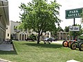
Park Motel


| Population development | |||
|---|---|---|---|
| Census | Residents | ± in% | |
| 1870 | 326 | - | |
| 1880 | 1441 | 342% | |
| 1890 | 1782 | 23.7% | |
| 1900 | 2771 | 55.5% | |
| 1910 | 3133 | 13.1% | |
| 1920 | 3581 | 14.3% | |
| 1930 | 3905 | 9% | |
| 1940 | 4361 | 11.7% | |
| 1950 | 4554 | 4.4% | |
| 1960 | 4930 | 8.3% | |
| 1970 | 6218 | 26.1% | |
| 1980 | 6675 | 7.3% | |
| 1990 | 6604 | -1.1% | |
| 2000 | 7339 | 11.1% | |
| 2010 | 8298 | 13.1% | |
| 2013 estimate | 8457 | 1.9% | |
| 1870-2000 2010-2013 | |||
population
According to the 2010 census , Denison had 8,298 people in 2,816 households. The population density was 487.5 people per square kilometer. Statistically, there were 2.75 people in each of the 2,816 households.
The racial the population was composed of 70.6 percent white, 2.3 percent African American, 0.6 percent Native American, 1.0 percent Asian, 0.2 percent Polynesian and 23.0 percent from other ethnic groups; 2.3 percent were descended from two or more races. Regardless of ethnicity, 42.1 percent of the population was Hispanic or Latino of any race.
29.0 percent of the population were under 18 years old, 57.1 percent were between 18 and 64 and 13.9 percent were 65 years or older. 49.3 percent of the population were female.
The average annual income for a household was 43,639 USD . The per capita income was $ 19,042. 20.3 percent of the population lived below the poverty line.
Known residents
- Clarence Duncan Chamberlin (1893–1976) - aviation pioneer - born and raised in Denison
- James Perry Conner (1851-1924) - Republican member of the US House of Representatives (1900-1909) - lived for a long time in Denison and is buried here
- Jim Garrison (1921–1992) - New Orleans District Attorney (1962–1973) - born in Denison
- James E. Hansen (* 1941) - climate researcher - born and raised in Denison
- Freeman Knowles (1846–1910) - Democratic MP for the US House of Representatives (1897–1899) - practiced as a lawyer in Denison for many years
- Hans F. Koenekamp (1891–1992) - special effects artist and cameraman - born in Denison
- Donna Reed (1921–1986) - actress - born and raised in Denison
- LM Shaw (1848–1932) - 17th Governor of Iowa (1898–1902) and US Treasury Secretary (1902–1907) - lived in Denison and is buried here
Individual evidence
- ↑ US Postal Service - ZIP Codes Retrieved December 11, 2014
- ↑ City of Denison - City Council.Retrieved December 11, 2014
- ↑ Extract from the National Register of Historic Places - No. 81000232. Accessed December 11, 2014
- ↑ a b c American Fact Finder. Retrieved December 11, 2014
- ↑ Distance information according to Google Maps. Accessed December 11, 2014
- ↑ AirNav.com - Denison Municipal Airport Retrieved on December 11, 2014
- ↑ State Data Center of Iowa (PDF; 86 kB) Retrieved December 11, 2014