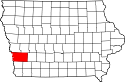
Pottawattamie County
 The Pottawattamie County Courthouse in Council Bluffs |
|
| administration | |
|---|---|
| US state : | Iowa |
| Administrative headquarters : | Council bluffs |
| Address of the administrative headquarters: |
County Courthouse 227 South Sixth Street Council Bluffs, IA 51501-4269 |
| Foundation : | September 21, 1848 |
| Made up from: | Original County |
| Area code : | 001 712 |
| Demographics | |
| Residents : | 93,158 (2010) |
| Population density : | 37.7 inhabitants / km 2 |
| geography | |
| Total area : | 2486 km² |
| Water surface : | 15 km² |
| map | |
| Website : co.pottawattamie.ia.us | |
The Pottawattamie County is a county in the US -amerikanischen State Iowa . In 2010 , the county had 93,158 residents and a population density of 37.7 people per square kilometer. By 2014, the population decreased slightly to 93,128. The county seat is Council Bluffs .
The Pottawattamie County is part of both sides of the Missouri in the states of Iowa and Nebraska situated metropolitan Omaha -Council Bluffs.
| Population development | |||
|---|---|---|---|
| Census | Residents | ± in% | |
| 1850 | 7828 | - | |
| 1860 | 4968 | -36.5% | |
| 1870 | 16,893 | 240% | |
| 1880 | 39,850 | 135.9% | |
| 1890 | 47,430 | 19% | |
| 1900 | 54,336 | 14.6% | |
| 1910 | 55,832 | 2.8% | |
| 1920 | 61,550 | 10.2% | |
| 1930 | 69,888 | 13.5% | |
| 1940 | 66,756 | -4.5% | |
| 1950 | 69,682 | 4.4% | |
| 1960 | 83.102 | 19.3% | |
| 1970 | 86,991 | 4.7% | |
| 1980 | 86,561 | -0.5% | |
| 1990 | 82,628 | -4.5% | |
| 2000 | 87,704 | 6.1% | |
| 2010 | 93,158 | 6.2% | |
| 2014 estimate | 93,128 | -0% | |
| Before 1900 1900–1990 2000 2010–2013 | |||
geography
The county is located in southwest Iowa at the confluence of the Boyer River with the Missouri River , which forms the border with Nebraska .
Pottawami County covers an area of 2,486 square kilometers, of which 15 square kilometers are water.
The following neighboring counties border Pottawatami County:
|
Washington County, Nebraska |
Harrison County | Shelby County |
|
Douglas County, Nebraska |

|
Cass County |
|
Sarpy County, Nebraska |
Mills County | Montgomery County |
history
Pottawattamie County was formed on September 21, 1848. It was named after the American Tribe of Potawatomi .
population
According to the 2010 census , Pottawattamie County had 93,158 people in 36,325 households. The population density was 37.7 inhabitants per square kilometer. Statistically, 2.46 people lived in each of the 36,325 households.
The racial the population was composed of 92.9 percent white, 1.4 percent African American, 0.5 percent Native American, 0.6 percent Asian and other ethnic groups; 1.9 percent were descended from two or more races. Hispanic or Latino of any race was 6.6 percent of the population.
24.1 percent of the population were under 18 years old, 61.6 percent were between 18 and 64 and 14.3 percent were 65 years or older. 51.0 percent of the population was female.
The median income for a household was 48,728 USD . The per capita income was $ 23,782. 12.1 percent of the population lived below the poverty line.
Localities
Incorporated cities and non-incorporated census-designated places (CDP) :
| place | Residents 2010 |
Residents 2014 |
Type |
|---|---|---|---|
| Council bluffs | 62,230 | 62,245 | City |
| Carter Lake | 3785 | 3766 | City |
| Oakland | 1527 | 1506 | City |
| Avoca | 1506 | 1506 | City |
| Treynor | 919 | 940 | City |
| Underwood | 917 | 938 | City |
| Neola | 842 | 856 | City |
| Carson | 812 | 812 | City |
| Walnut | 785 | 773 | City |
| Shelby 1 | 641 | 620 | City |
| Crescent | 617 | 622 | City |
| Minden | 599 | 592 | City |
| Macedonia | 246 | 244 | City |
| Hancock | 196 | 194 | City |
| McClelland | 151 | 150 | City |
| Bentley | 118 | 106 | CDP |
| Weston | 92 | 153 | CDP |
| Loveland | 35 | 37 | CDP |
1 - partially in Shelby County
Unincorporated communities not recorded separately from the census :
1 - partially in Shelby County
structure
Pottawattamie County is divided into 29 townships :
|
|
|
See also
Individual evidence
- ↑ GNIS-ID: 465266. Retrieved on February 22, 2011 (English).
- ↑ a b c U.S. Census Bureau, State & County QuickFacts - Pottawattamie County, IA. Retrieved October 14, 2015
- ↑ a b National Association of Counties.Retrieved October 14, 2015
- ^ US Census Bureau - Census of Population and Housing.Retrieved March 15, 2011
- ^ Extract from Census.gov.Retrieved February 16, 2011
- ↑ a b American Fact Finder.Retrieved October 14, 2015
- ↑ Missouri Census Data Center - Iowa ( January 21, 2016 memento on the Internet Archive ). Retrieved October 14, 2015
Web links
Coordinates: 41 ° 20 ′ N , 95 ° 33 ′ W
