Tama County
![The Tama County Courthouse in Toledo, listed in NRHP No. 81000269 [1]](https://upload.wikimedia.org/wikipedia/commons/thumb/5/58/Tama_county_courthouse.jpg/298px-Tama_county_courthouse.jpg) The Tama County Courthouse in Toledo, listed on NRHP No. 81000269 |
|
| administration | |
|---|---|
| US state : | Iowa |
| Administrative headquarters : | Toledo |
| Address of the administrative headquarters: |
County Courthouse 100 West High Street Toledo, IA 52342-1333 |
| Foundation : | February 17, 1843 |
| Made up from: | Benton County |
| Area code : | 001 641 |
| Demographics | |
| Residents : | 17,767 (2010) |
| Population density : | 9.5 inhabitants / km 2 |
| geography | |
| Total area : | 1871 km² |
| Water surface : | 3 km² |
| map | |
| Website : www.tamacounty.org | |
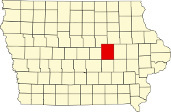
The Tama County is a county in the US -amerikanischen State Iowa . In 2010 , the county had 17,767 residents and a population density of 9.5 people per square kilometer. By 2013 the population had decreased to 17,576. The county seat is Toledo , named after Toledo in Ohio .
In Tama County is the tribal area of the officially recognized by the US government Sac and Fox Tribe of the Mississippi in Iowa , part of the Sauk and Fox . It is after Taimah, a former chief of the Fox - Indians named.
geography
The county is located in east-central Iowa and has an area of 1,871 square kilometers, of which three square kilometers are water.
The south of the county is traversed by the Iowa River , a right tributary of the Mississippi .
The following neighboring counties border Tama County:
| Grundy County | Black Hawk County | |
| Marshall County |

|
Benton County |
| Jasper County | Poweshiek County | Iowa County |
history
| Population development | |||
|---|---|---|---|
| Census | Residents | ± in% | |
| 1850 | 8th | - | |
| 1860 | 5285 | 65,962.5% | |
| 1870 | 16,131 | 205.2% | |
| 1880 | 21,585 | 33.8% | |
| 1890 | 21,651 | 0.3% | |
| 1900 | 24,585 | 13.6% | |
| 1910 | 22,156 | -9.9% | |
| 1920 | 21,861 | -1.3% | |
| 1930 | 21,987 | 0.6% | |
| 1940 | 22,428 | 2% | |
| 1950 | 21,688 | -3.3% | |
| 1960 | 21,413 | -1.3% | |
| 1970 | 20,147 | -5.9% | |
| 1980 | 19,533 | -3% | |
| 1990 | 17,419 | -10.8% | |
| 2000 | 18,103 | 3.9% | |
| 2010 | 17,767 | -1.9% | |
| 2013 estimate | 17,576 | -1.1% | |
| Before 1900 1900–1990 2000 2010–2013 | |||
Tama County was formed on February 17, 1843 from former parts of Benton County. It was named after Taimah, a chief of the Fox Indians.
population
According to the 2010 census , Tama County had 17,767 people in 7,058 households. The population density was 9.5 inhabitants per square kilometer. Statistically, 2.47 people lived in each of the 7058 households.
The racial the population was composed of 86.5 percent white, 0.3 percent African American, 7.5 percent Native American, 0.3 percent Asian and other ethnic groups; 2.5 percent were descended from two or more races. Hispanic or Latino of any race was 7.4 percent of the population.
25.6 percent of the population were under 18 years old, 56.0 percent were between 18 and 64 and 18.4 percent were 65 years or older. 50.9 percent of the population was female.
The median income for a household was 46,288 USD . The per capita income was $ 23,041. 10.6 percent of the population lived below the poverty line.
Localities
| place | Residents 2010 |
Residents 2013 |
|---|---|---|
| Tama | 2877 | 2842 |
| Toledo | 2341 | 2276 |
| Traer | 1703 | 1677 |
| Dysart | 1379 | 1376 |
| Gladbrook | 945 | 926 |
| Le Grand 1 | 938 | 939 |
| Garwin | 527 | 518 |
| Chelsea | 267 | 264 |
| Montour | 249 | 248 |
| Clutier | 213 | 212 |
| Elberon | 196 | 195 |
| Lincoln | 162 | 159 |
| Vining | 50 | 50 |
1 - partially in Marshall County
structure
Tama County is divided into 21 townships :
|
|
|
See also
Individual evidence
- ^ Extract from the National Register of Historic Places.Retrieved March 13, 2011
- ↑ GNIS-ID: 465274. Retrieved on February 22, 2011 (English).
- ↑ a b c U.S. Census Bureau, State & County QuickFacts - Tama County, IA. Retrieved March 21, 2015
- ↑ a b National Association of Counties.Retrieved March 21, 2015
- ^ Sac and Fox Tribe of the Mississippi, Iowa. Retrieved March 21, 2015
- ^ US Census Bureau - Census of Population and Housing.Retrieved March 15, 2011
- ^ Extract from Census.gov.Retrieved February 16, 2011
- ↑ a b American Fact Finder.Retrieved March 21, 2015
- ↑ 2010 US Census Iowa Township and Other Subdivision Population. Retrieved July 23, 2019 .
Web links
Coordinates: 42 ° 5 ′ N , 92 ° 32 ′ W

