Buchanan County, Iowa
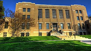
 Buchanan County Courthouse |
|
| administration | |
|---|---|
| US state : | Iowa |
| Administrative headquarters : | Independence |
| Address of the administrative headquarters: |
County Courthouse P.O. Box 317 Independence, IA 50644-0317 |
| Foundation : | December 21, 1837 |
| Made up from: | Dubuque County |
| Area code : | 001 319 |
| Demographics | |
| Residents : | 20,958 (2010) |
| Population density : | 14.2 inhabitants / km 2 |
| geography | |
| Total area : | 1485 km² |
| Water surface : | 5 km² |
| map | |
| Website : www.co.buchanan.ia.us | |
The Buchanan County is a county in the US -amerikanischen State Iowa . In 2010 , the county had 20,958 residents and a population density of 14.2 people per square kilometer. By 2013 the number of inhabitants increased slightly to 20,976. The county seat is Independence .
geography
The county is located in northeastern Iowa and is traversed by the Wapsipinicon River . It has an area of 1,485 square kilometers, of which five square kilometers are water. The following neighboring counties border Buchanan County:
| Bremer County | Fayette County | Clayton County |
| Black Hawk County |

|
Delaware County |
| Benton County | Linn County |
history
| Population development | |||
|---|---|---|---|
| Census | Residents | ± in% | |
| 1850 | 517 | - | |
| 1860 | 7906 | 1,429.2% | |
| 1870 | 17,034 | 115.5% | |
| 1880 | 18,546 | 8.9% | |
| 1890 | 18,997 | 2.4% | |
| 1900 | 21,427 | 12.8% | |
| 1910 | 19,748 | -7.8% | |
| 1920 | 19,890 | 0.7% | |
| 1930 | 19,550 | -1.7% | |
| 1940 | 20,991 | 7.4% | |
| 1950 | 21,927 | 4.5% | |
| 1960 | 22,293 | 1.7% | |
| 1970 | 21,746 | -2.5% | |
| 1980 | 22,900 | 5.3% | |
| 1990 | 20,844 | -9% | |
| 2000 | 21.093 | 1.2% | |
| 2010 | 20,958 | -0.6% | |
| 2013 estimate | 20,976 | 0.1% | |
| Before 1900 1900–1990 2000 2010–2013 | |||
Buchanan County was formed on December 21, 1837 in what was then the Wisconsin Territory from parts of Dubuque County. It was named after James Buchanan (1791–1868), the 15th President of the United States (1857–1861).
The first documented permanent white settler in the area was William Bennett, who built a log cabin here in February 1842. The county's first election was held in 1847, in which John Scott, Frederick Kessler and BD Springer were elected as representatives of the people. The first county courthouse was completed in May 1858. Construction of today's courthouse began in November 1938.
population
According to the 2010 census , Buchanan County had 20,958 people in 8,391 households. The population density was 14.2 inhabitants per square kilometer. Statistically, there were 2.44 people in each of the 8,391 households.
The racial the population was composed of 97.8 percent white, 0.3 percent African American, 0.2 percent Native American, 0.4 percent Asian and other ethnic groups; 1.1 percent were descended from two or more races. Hispanic or Latino of any race was 1.2 percent of the population.
27.1 percent of the population were under 18 years old, 57.6 percent were between 18 and 64 and 15.3 percent were 65 years or older. 50.4 percent of the population was female.
The median income for a household was 51,052 USD . The per capita income was $ 23,897. 10.9 percent of the population lived below the poverty line.
Buchanan County localities
1 - partly in Fayette County
2 - partly in Black Hawk County
structure
Buchanan County is divided into 16 townships :
|
|
See also
Individual evidence
- ↑ Buchanan County ( English ) In: Geographic Names Information System . United States Geological Survey . Retrieved February 23, 2011.
- ↑ a b c U.S. Census Bureau, State & County QuickFacts - Buchanan County, IA. Retrieved October 22, 2014
- ^ A b National Association of Counties.Retrieved October 23, 2011
- ^ US Census Bureau - Census of Population and Housing.Retrieved March 15, 2011
- ^ Extract from Census.gov.Retrieved February 16, 2011
- ↑ Buchanan County Iowa - History (By Anthony Bengston, Buchanan County Recorder Office, Fairbank, Iowa) ( December 1, 2012 memento from the Internet Archive ) Retrieved February 21, 2011
- ↑ 2010 US Census Iowa Township and Other Subdivision Population. Retrieved July 23, 2019 .
Web links
Coordinates: 42 ° 28 ′ N , 91 ° 50 ′ W

