Cerro Gordo County
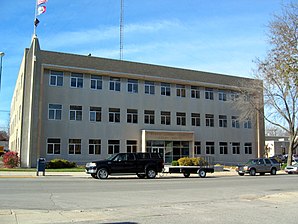
 The Cerro Gordo County Courthouse in Mason City |
|
| administration | |
|---|---|
| US state : | Iowa |
| Administrative headquarters : | Mason City |
| Address of the administrative headquarters: |
Cerro Gordo County Courthouse 220 North Washington Avenue Mason City, Iowa 50401 |
| Foundation : | 1851 |
| Area code : | 001 641 |
| Demographics | |
| Residents : | 44,151 (2010) |
| Population density : | 30 inhabitants / km 2 |
| geography | |
| Total area : | 1490 km² |
| Water surface : | 18 km² |
| map | |
| Website : www.co.cerro-gordo.ia.us | |
The Cerro Gordo County is a county in the US -amerikanischen State Iowa . In 2010 the county had 44,151 residents and a population density of 30 people per square kilometer. By 2013 the population had decreased to 43,575. The county seat is Mason City .
geography
The county is located in northern Iowa, about 180 kilometers west of the border with Wisconsin forming Mississippi . The Minnesota border runs approximately 30 km north.
Cerro Gordo County covers an area of 1490 square kilometers, of which 18 square kilometers are water.
The county is traversed by the Winnebago River and the Shell Rock River , which belong to the Mississippi River basin via the Cedar River and the Iowa River .
The following neighboring counties border Cerro Gordo County:
| Winnebago County | Worth County | Mitchell County |
| Hancock County |

|
Floyd County |
| Wright County | Franklin County | Butler County |
traffic
Interstate 35 and US Highway 65 run through the county in a north-south direction , and US Highway 18 in an east-west direction .
history
| Population development | |||
|---|---|---|---|
| Census | Residents | ± in% | |
| 1860 | 940 | - | |
| 1870 | 4722 | 402.3% | |
| 1880 | 11,461 | 142.7% | |
| 1890 | 14,864 | 29.7% | |
| 1900 | 20,672 | 39.1% | |
| 1910 | 25,011 | 21% | |
| 1920 | 34,675 | 38.6% | |
| 1930 | 38,476 | 11% | |
| 1940 | 43,845 | 14% | |
| 1950 | 46.053 | 5% | |
| 1960 | 49,894 | 8.3% | |
| 1970 | 49,335 | -1.1% | |
| 1980 | 48,458 | -1.8% | |
| 1990 | 46,733 | -3.6% | |
| 2000 | 46,447 | -0.6% | |
| 2010 | 44.151 | -4.9% | |
| 2013 estimate | 43,575 | -1.3% | |
| Before 1900 1900–1990 2000 2010–2013 | |||
Cerro Gordo County was formed in 1851 and named after a battlefield in the Mexican-American War in which General Winfield Scott defeated Mexican General Santa Ana on April 18, 1847.
The first white settlers came to what is now the county in 1851 and settled on Clear Lake. Four years later, on August 7, 1855, the first elections were held and the first trial took place in 1857. In the summer of the same year Livonia was chosen as the new district capital.
In 1858 the seat was moved back to Mason City. In 1866, the first stone courthouse was built for $ 600 and was in use until 1900. The courthouse, which is still in use today, was put into operation on November 17, 1960 and expanded in 1999 with a first extension for the sheriff's office and in 2000 with another extension for prisoners.
population
According to the 2010 census , Cerro Gordo County had 44,151 people in 19,399 households. The population density was 30 people per square kilometer. Statistically, there were 2.20 people each in the 19,399 households.
The racial the population was composed of 95.0 percent white, 1.3 percent African American, 0.2 percent Native American, 0.9 percent Asian and other ethnic groups; 1.6 percent were descended from two or more races. Regardless of ethnicity, 3.8 percent of the population was Hispanic or Latino of any race.
21.5 percent of the population were under 18 years old, 60.6 percent were between 18 and 64 and 17.9 percent were 65 years or older. 51.2 percent of the population was female.
The median income for a household was 44,494 USD . The per capita income was $ 25,332. 10.6 percent of the population lived below the poverty line.
Localities in Cerro Gordo County
Census-designated places (CDP)
Other Unincorporated Communities
1 - partially in Floyd County
structure
Cerro Gordo County is divided into 16 townships :
|
|
The cities of Clear Lake and Mason City are not part of any township.
See also
Individual evidence
- ↑ Cerro Gordo County ( English ) In: Geographic Names Information System . United States Geological Survey . Retrieved January 14, 2011.
- ↑ a b c U.S. Census Bureau, State & County QuickFacts - Cerro Gordo County, Iowa. Retrieved September 28, 2014
- ↑ a b National Association of Counties.Retrieved September 28, 2014
- ^ US Census Bureau - Census of Population and Housing.Retrieved March 15, 2011
- ^ Extract from Census.gov.Retrieved February 16, 2011
- ↑ 2010 US Census Iowa Township and Other Subdivision Population. Retrieved July 23, 2019 .
Web links
Coordinates: 43 ° 5 ′ N , 93 ° 16 ′ W

