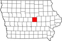
Marshall County, Iowa
![The Marshall County Courthouse in Marshalltown, listed on the NRHP since 1972 [1]](https://upload.wikimedia.org/wikipedia/commons/thumb/9/96/Marshall_County_Courthouse_DH.jpg/298px-Marshall_County_Courthouse_DH.jpg) The Marshall County Courthouse in Marshalltown, listed on the NRHP since 1972 |
|
| administration | |
|---|---|
| US state : | Iowa |
| Administrative headquarters : | Marshalltown |
| Address of the administrative headquarters: |
County Courthouse 1 East Main Street Marshalltown, IA 50158-4915 |
| Foundation : | January 13, 1846 |
| Made up from: | Jasper County |
| Area code : | 001 641 |
| Demographics | |
| Residents : | 40,648 (2010) |
| Population density : | 27.4 inhabitants / km 2 |
| geography | |
| Total area : | 1484 km² |
| Water surface : | 2 km² |
| map | |
| Website : www.co.marshall.ia.us | |
The Marshall County is a county in the US -amerikanischen State Iowa . In 2010 the county had 40,648 residents and a population density of 27.4 people per square kilometer. By 2013 the population increased to 40,994. The county seat is Marshalltown .
geography
The county is east of the geographic center of Iowa and has an area of 1,484 square kilometers, of which two square kilometers are water.
The northeast of the county is traversed by the Iowa River , a right tributary of the Mississippi .
The following neighboring counties border Marshall County:
| Hardin County Grundy County | ||
| Story County |

|
Tama County |
| Jasper County | Poweshiek County |
history
Marshall County was formed on January 13, 1846 from former parts of Jasper County. It was named after John Marshall (1755-1835), a former Secretary of State (1800-1801) and Chief Justice of the United States (1801-1835).
population
| Population development | |||
|---|---|---|---|
| Census | Residents | ± in% | |
| 1850 | 338 | - | |
| 1860 | 6015 | 1,679.6% | |
| 1870 | 17,576 | 192.2% | |
| 1880 | 23,752 | 35.1% | |
| 1890 | 25,742 | 8.4% | |
| 1900 | 29,991 | 16.5% | |
| 1910 | 30,279 | 1 % | |
| 1920 | 32,630 | 7.8% | |
| 1930 | 33,727 | 3.4% | |
| 1940 | 35,406 | 5% | |
| 1950 | 35,611 | 0.6% | |
| 1960 | 37,984 | 6.7% | |
| 1970 | 41,076 | 8.1% | |
| 1980 | 41,652 | 1.4% | |
| 1990 | 38.276 | -8.1% | |
| 2000 | 39,311 | 2.7% | |
| 2010 | 40,648 | 3.4% | |
| 2013 estimate | 40.994 | 0.9% | |
| Before 1900 1900–1990 2000 2010–2013 | |||
According to the 2010 census , Marshall County had 40,648 people in 15,681 households. The population density was 27.4 inhabitants per square kilometer. Statistically, 2.39 people lived in each of the 15,681 households.
The racial the population was composed of 88.7 percent white, 1.7 percent African American, 0.5 percent Native American, 1.3 percent Asian and other ethnic groups; 2.0 percent were descended from two or more races. Regardless of ethnicity, 17.3 percent of the population was Hispanic or Latino of any race.
25.3 percent of the population were under 18 years old, 58.3 percent were between 18 and 64 and 16.4 percent were 65 years or older. 49.7 percent of the population was female.
The median income for a household in the county was $ 45,190 . The per capita income was $ 23,000. 12.6 percent of the population lived below the poverty line.
Localities
Citys and Census-designated places (CDP) :
| place | Residents 2010 |
Residents 2013 |
Type |
|---|---|---|---|
| Marshalltown | 27,552 | 27,844 | City |
| State Center | 1468 | 1479 | City |
| Le Grand 1 | 938 | 939 | City |
| Melbourne | 830 | 822 | City |
| Gilman | 509 | 511 | City |
| Albion | 505 | 471 | City |
| Rhodes | 305 | 310 | City |
| Liscomb | 301 | 298 | City |
| Laurel | 239 | 243 | City |
| Haverhill | 173 | 176 | City |
| Clemons | 148 | 150 | City |
| Ferguson | 126 | 128 | City |
| Green Mountain | 126 | CDP | |
| St. Anthony | 102 | 104 | City |
1 - partially in Tama County
Other unincorporated communities not recorded separately from the census :
structure
Marshall County is divided into 16 townships :
|
|
See also
- Marshall County Courthouse
- List of entries on the National Register of Historic Places in Marshall County, Iowa
Individual evidence
- ↑ Extract from the National Register of Historic Places - No. 72000478. Retrieved January 20, 2012
- ↑ Marshall County in the Geographic Names Information System of the United States Geological Survey Accessed 26 February 2011
- ↑ a b c U.S. Census Bureau, State & County QuickFacts - Marshall County, IA ( July 14, 2011 memento on WebCite ) Retrieved March 28, 2015
- ↑ a b National Association of Counties.Retrieved March 28, 2015
- ^ US Census Bureau - Census of Population and Housing.Retrieved March 15, 2011
- ^ Extract from Census.gov.Retrieved February 16, 2011
- ↑ a b American Fact Finder.Retrieved March 28, 2015
- ↑ 2010 US Census Iowa Township and Other Subdivision Population. Retrieved July 23, 2019 .
Web links
Coordinates: 42 ° 2 ′ N , 93 ° 0 ′ W

