Mills County, Iowa
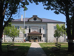
 The Mills County Courthouse in Glenwood |
|
| administration | |
|---|---|
| US state : | Iowa |
| Administrative headquarters : | Glenwood |
| Address of the administrative headquarters: |
County Courthouse 418 Sharp Street Glenwood, IA 51534-1774 |
| Foundation : | 1851 |
| Made up from: | Pottawattamie County |
| Area code : | 001 712 |
| Demographics | |
| Residents : | 15,059 (2010) |
| Population density : | 13.3 inhabitants / km 2 |
| geography | |
| Total area : | 1139 km² |
| Water surface : | 8 km² |
| map | |
| Website : www.millscoia.us | |
The Mills County is a county in the US state of Iowa . At the 2010 census , the county had 15,059 people and a population density of 13.3 people per square kilometer. The county seat is Glenwood .
Mills County is part of the metropolitan area of Omaha-Council Bluffs .
geography
The county is located in southwest Iowa on the east bank of the Missouri River , which forms the border with Nebraska . There, on the opposite bank, the Platte River, one of its largest tributaries, flows into the Missouri. About 25 miles south of Mills County is the border with the state of Missouri . Mills County covers an area of 1,139 square kilometers, of which eight square kilometers are water. It borders on the following neighboring counties:
| Pottawattamie County | ||
|
Sarpy County, Nebraska |

|
Montgomery County |
|
Cass County, Nebraska |
Fremont County | Page County |
history

The first white settlement was founded by Mormons in 1846 and named Rushville. After the place was first renamed Coonsville, it was given the current name Glenwood in 1853 .
Mills County was formed in 1851 from former parts of Pottawattamie County. It was named after Major Frederick Mills , a young officer from Burlington, Iowa , who died in the Mexican-American War in 1847 .
The first court and administrative building was a 6 m by 3.5 m building that gave way to a new two-story house in 1857. In 1900 the building was expanded and a clock tower followed in 1910. In 1959 a new courthouse was built, which still fulfills this function today.
Mills County has a National Historic Landmark , the Davis Oriole Earthlodge Site . Four other structures and sites in the county are on the National Register of Historic Places .
Demographic data
| growth of population | |||
|---|---|---|---|
| Census | Residents | ± in% | |
| 1860 | 4481 | - | |
| 1870 | 8718 | 94.6% | |
| 1880 | 14,137 | 62.2% | |
| 1890 | 14,548 | 2.9% | |
| 1900 | 16,764 | 15.2% | |
| 1910 | 15,811 | -5.7% | |
| 1920 | 15,422 | -2.5% | |
| 1930 | 15,866 | 2.9% | |
| 1940 | 15,064 | -5.1% | |
| 1950 | 14,064 | -6.6% | |
| 1960 | 13,050 | -7.2% | |
| 1970 | 11.606 | -11.1% | |
| 1980 | 13,406 | 15.5% | |
| 1990 | 13,202 | -1.5% | |
| 2000 | 14,547 | 10.2% | |
| 2010 | 15,059 | 3.5% | |
| Before 1900 1900–1990 2000–2010 | |||
According to the 2010 census , Mills County had 15,059 people in 5,406 households. The population density was 13.3 inhabitants per square kilometer.
The racial the population was composed of 97.2 percent white, 0.4 percent African American, 0.3 percent Native American, 0.4 percent Asian and other ethnic groups; 1.1 percent were descended from two or more races. Hispanic or Latino of any race was 2.4 percent of the population.
Statistically, 2.55 people lived in each of the 5,406 households.
25.4 percent of the population were under 18 years old, 61.2 percent were between 18 and 64 and 13.4 percent were 65 years or older. 49.7 percent of the population was female.
The median income for a household was 54,646 USD . The per capita income was $ 24,554. 9.1 percent of the population lived below the poverty line.
Places in Mills County
1 - partially in Fremont County
structure
Mills County is divided into 13 townships :
Individual evidence
- ^ Mills County in the United States Geological Survey's Geographic Names Information System.Retrieved February 28, 2011
- ^ National Association of Counties.Retrieved January 21, 2012
- ↑ Extract from the National Register of Historic Places - No. 92000755.Retrieved January 21, 2012.
- ^ Mills County History ( October 19, 2013 memento on the Internet Archive ). Retrieved January 21, 2012.
- ↑ Listing of National Historic Landmarks by State: Iowa . National Park Service , accessed August 26, 2017.
- ↑ Search mask database in the National Register Information System. National Park Service , accessed August 26, 2017.
- ^ US Census Bureau - Census of Population and Housing.Retrieved March 15, 2011
- ^ Extract from Census.gov.Retrieved February 16, 2011
- ↑ a b U.S. Census Bureau, State & County QuickFacts - Mills County, IA ( July 14, 2011 memento on WebCite ) Retrieved January 21, 2012
- ↑ 2010 US Census Iowa Township and Other Subdivision Population. Retrieved July 23, 2019 .
Web links
- Official website
- Mills County Chamber of Commerce in Glenwood
- Mills County Iowa Department of Tourism
- www.city-data.com
Coordinates: 41 ° 2 ′ N , 95 ° 37 ′ W
