
Dubuque County
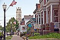
![The Dubuque County Courthouse in Dubuque, listed on NRHP No. 71000298 [1]](https://de.wikipedia.org/wiki/Datei:Dubuque_County_Courthouse.jpg) The Dubuque County Courthouse in Dubuque, listed on NRHP No. 71000298 |
|
| administration | |
|---|---|
| US state : | Iowa |
| Administrative headquarters : | Dubuque |
| Address of the administrative headquarters: |
County Courthouse 720 Central Avenue Dubuque, IA 52001-7033 |
| Foundation : | October 1, 1834 |
| Made up from: | Michigan Territory |
| Area code : | 001 563 |
| Demographics | |
| Residents : | 93,653 (2010) |
| Population density : | 59.5 inhabitants / km 2 |
| geography | |
| Total area : | 1597 km² |
| Water surface : | 22 km² |
| map | |
 |
|
| Website : www.dubuquecounty.org | |
The Dubuque County is a county in the US -amerikanischen State Iowa . In 2010 the county had 93,653 residents and a population density of 59.5 people per square kilometer. By 2013 the population increased to 95,697. The county seat is Dubuque .
geography
The county is located in eastern Iowa on the border with Wisconsin and Illinois , which is formed by the Mississippi River . Dubuque County has an area of 1597 square kilometers, of which 22 square kilometers are water. It borders on the following neighboring counties:
| Clayton County |
Grant County, Wisconsin |
|
| Delaware County |
.svg)
|
Jo Daviess County, Illinois |
| Jones County | Jackson County |
traffic
The oldest traffic route is the Mississippi, on which an important part of the flow of goods is still transported through the center of the USA. The river is kept navigable for large barges by dams, of which Lock and Dam No. 11 one located in Dubuque County.
By Dubuque Iowa County of the section runs parallel to the Mississippi Great River Road forming US Highway 52 . In the city of Dubuque this meets the US Highways 20 and 61 and the US Highway 151, which has been converted into a freeway . The Highway 20 leads over the Julien Dubuque Bridge to Illinois, the Highways 61 and 151 lead together over the Dubuque - Wisconsin Bridge to Wisconsin.
A line of the Canadian Pacific Railway runs through Dubuque County on the west bank of the Mississippi . In the city of Dubuque this crosses a stretch of the Canadian National Railway , which, coming from the west, crosses the single-track Dubuque Rail Bridge in the direction of Illinois.
Dubuque County has an airport, Dubuque Regional Airport , which connects the region to the national and international air traffic network with feeder flights to Chicago O'Hare .
history
Dubuque County was formed on October 1, 1834 on what was then the Michigan Territory . It was named after Julien Dubuque (1762-1810), one of the first white settlers in the area.
Historical objects

Dubuque County Jail in Dubuque, listed on the NRHP since 1972

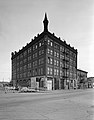
Dubuque City Hall , listed on the NRHP since 1972
Cathedral Historic District in Dubuque, listed on the NRHP since 1985

Basilica of St. Francis Xavier in Dubuque, listed in the NRHP since 1999
Bishop's Block in Dubuque, listed on the NRHP since 1994

Julien Dubuque Bridge from Dubuque to Illinois, listed in the NRHP since 1999

St. Boniface in New Vienna, listed in the NRHP since 1999

Lock and dam No. 11 overlooking the Wisconsin shore, listed on the NRHP since 2004
.jpg)


| Population development | |||
|---|---|---|---|
| Census | Residents | ± in% | |
| 1840 | 3059 | - | |
| 1850 | 10,841 | 254.4% | |
| 1860 | 31,164 | 187.5% | |
| 1870 | 38,969 | 25% | |
| 1880 | 42,996 | 10.3% | |
| 1890 | 49,848 | 15.9% | |
| 1900 | 56,403 | 13.1% | |
| 1910 | 57,450 | 1.9% | |
| 1920 | 58,262 | 1.4% | |
| 1930 | 61.214 | 5.1% | |
| 1940 | 63,768 | 4.2% | |
| 1950 | 71,337 | 11.9% | |
| 1960 | 80,048 | 12.2% | |
| 1970 | 90,609 | 13.2% | |
| 1980 | 93,745 | 3.5% | |
| 1990 | 86,403 | -7.8% | |
| 2000 | 89.143 | 3.2% | |
| 2010 | 93,653 | 5.1% | |
| 2013 estimate | 95,697 | 2.2% | |
| Before 1900 1900–1990 2000 2010–2013 | |||
population
According to the 2010 census , Dubuque County had 93,653 people in 36,962 households. The population density was 59.5 inhabitants per square kilometer. Statistically, 2.37 people lived in each of the 36,962 households.
The racial the population was composed of 94.1 percent white, 2.7 percent African American, 0.2 percent Native American, 0.9 percent Asian and other ethnic groups; 1.3 percent were descended from two or more races. Hispanic or Latino of any race was 1.9 percent of the population.
23.8 percent of the population were under 18 years old, 60.9 percent were between 18 and 64 and 15.3 percent were 65 years or older. 50.7 percent of the population was female.
The median income for a household was 46,894 USD . The per capita income was $ 24,455. 9.5 percent of the population lived below the poverty line.
Localities in Dubuque County
structure
Dubuque County is divided into 17 townships :
|
|

The city of Dubuque does not belong to any township.
See also
Individual evidence
- ^ Extract from the National Register of Historic Places.Retrieved March 13, 2011
- ^ Dubuque County ( English ) In: Geographic Names Information System . United States Geological Survey . Retrieved February 23, 2011.
- ↑ a b c U.S. Census Bureau, State & County QuickFacts - Dubuque County, IA ( July 9, 2011 memento on WebCite ) Retrieved January 6, 2015
- ↑ a b National Association of Counties.Retrieved January 6, 2015
- ↑ Extract from the National Register of Historic Places - No. 72000473. Retrieved December 1, 2011
- ↑ Extract from the National Register of Historic Places - No. 72000472. Retrieved December 1, 2011
- ↑ Extract from the National Register of Historic Places - No. 85002501. Retrieved December 1, 2011
- ↑ Extract from the National Register of Historic Places - No. 99001205.Retrieved December 1, 2011
- ↑ Extract from the National Register of Historic Places - No. 94000477. Retrieved December 1, 2011
- ↑ Extract from the National Register of Historic Places - No. 99001034.Retrieved December 1, 2011
- ↑ Extract from the National Register of Historic Places - No. 99001207.Retrieved December 1, 2011
- ↑ Extract from the National Register of Historic Places - No. 04000171. Retrieved March 29, 2012
- ^ US Census Bureau - Census of Population and Housing.Retrieved March 15, 2011
- ^ Extract from Census.gov.Retrieved February 16, 2011
- ↑ 2010 US Census Iowa Township and Other Subdivision Population. Retrieved July 23, 2019 .
Web links
List of counties in Iowa
Adair |
Adams |
Allamakee |
Appanoosis |
Audubon |
Benton |
Black Hawk |
Boone |
Bremer |
Buchanan |
Buena Vista |
Butler |
Calhoun |
Carroll |
Cass |
Cedar |
Cerro Gordo |
Cherokee |
Chickasaw |
Clarke |
Clay |
Clayton |
Clinton |
Crawford |
Dallas |
Davis |
Decatur |
Delaware |
Des Moines |
Dickinson |
Dubuque |
Emmet |
Fayette |
Floyd |
Franklin |
Fremont |
Greene |
Grundy |
Guthrie |
Hamilton |
Hancock |
Hardin |
Harrison |
Henry |
Howard |
Humboldt |
Ida |
Iowa |
Jackson |
Jasper |
Jefferson |
Johnson |
Jones |
Keokuk |
Kossuth |
Lee |
Linn |
Louisa |
Lucas |
Lyon |
Madison |
Mahaska |
Marion |
Marshall |
Mills |
Mitchell |
Monona |
Monroe |
Montgomery |
Muscatine |
O'Brien |
Osceola |
Page |
Palo Alto |
Plymouth |
Pocahontas |
Polk |
Pottawattamy |
Poweshiek |
Ring gold |
Sac |
Scott |
Shelby |
Sioux |
Story |
Tama |
Taylor |
Union |
Van Buren |
Wapello |
Warren |
Washington |
Wayne |
Webster |
Winnebago |
Winneshiek |
Woodbury |
Worth |
Wright
Coordinates: 42 ° 28 ′ N , 90 ° 53 ′ W